
The assessment of LiDAR performance increasingly depends on workflows and data quality rather than catalog specifications. At Geo Week 2026 (Denver, February 16–18), surveying and geospatial professionals gain first-hand exposure to airborne, mobile, UAV and topo-bathymetric laser scanning systems through demonstrations and technical discussions led by industry actors including RIEGL’s engineering team.
The technical evaluation of laser scanning systems has evolved substantially over the past decade. While early adoption was driven by novelty and platform availability, current deployments reflect mature requirements from surveying, geospatial engineering and infrastructure asset management. System performance is now judged through a chain of interconnected variables: ranging precision, multi-return capability, waveform sampling, platform stability, GNSS/INS integration, and post-processing workflows capable of producing high-quality deliverables at scale. Geo Week 2026, hosted in Denver from 16 to 18 February, illustrates this transition toward workflow-centric evaluation through live LiDAR demonstrations and structured technical interactions.
From Specifications to Data Quality
Technical sheets remain useful reference tools, yet they communicate an abstraction of performance. Surveying professionals increasingly request access to operational scenarios to observe the practical consequences of sensor geometry, scanning patterns, beam divergence and power settings under varying surface conditions. Real-world deployments must contend with heterogeneous targets—vegetation, infrastructure, water interfaces and vertical facades—requiring not just metric accuracy but stability in classification and point density distribution.
These requirements are particularly relevant for airborne and mobile mapping missions, where long linear trajectories demand GNSS/INS consistency, adequate mission planning and robust temporal synchronization between sensors. UAV-based systems, now widely adopted in surveying contexts, impose different constraints involving endurance, payload, regulatory considerations and take-off logistics.
Platform Typologies and Technical Trade-Offs
Geo Week offers a configuration in which these platforms can be compared directly. Airborne LiDAR remains the method of choice for corridor mapping and wide-area acquisitions, thanks to stable trajectories and refined inertial measurement strategies. Mobile mapping systems, deployed on road or rail vehicles, deliver high point densities and optimized geometry for vertical structures and road assets. UAV-based laser scanning adds flexibility and local granularity, particularly in areas with access restrictions or safety limitations. Topo-bathymetric LiDAR extends the domain across terrestrial and shallow aquatic environments, requiring dedicated wavelengths and receiver configurations for penetration of water columns.
These typologies illustrate trade-offs rather than categorical superiority. Airborne platforms optimize coverage, UAVs optimize localized detail, mobile platforms optimize structural context, and topo-bathymetric sensors solve interface complexity. Surveying professionals attending the event are able to observe how these trade-offs manifest in workflow and data output rather than relying solely on theoretical comparisons.
RIEGL’s Technical Presence at Geo Week
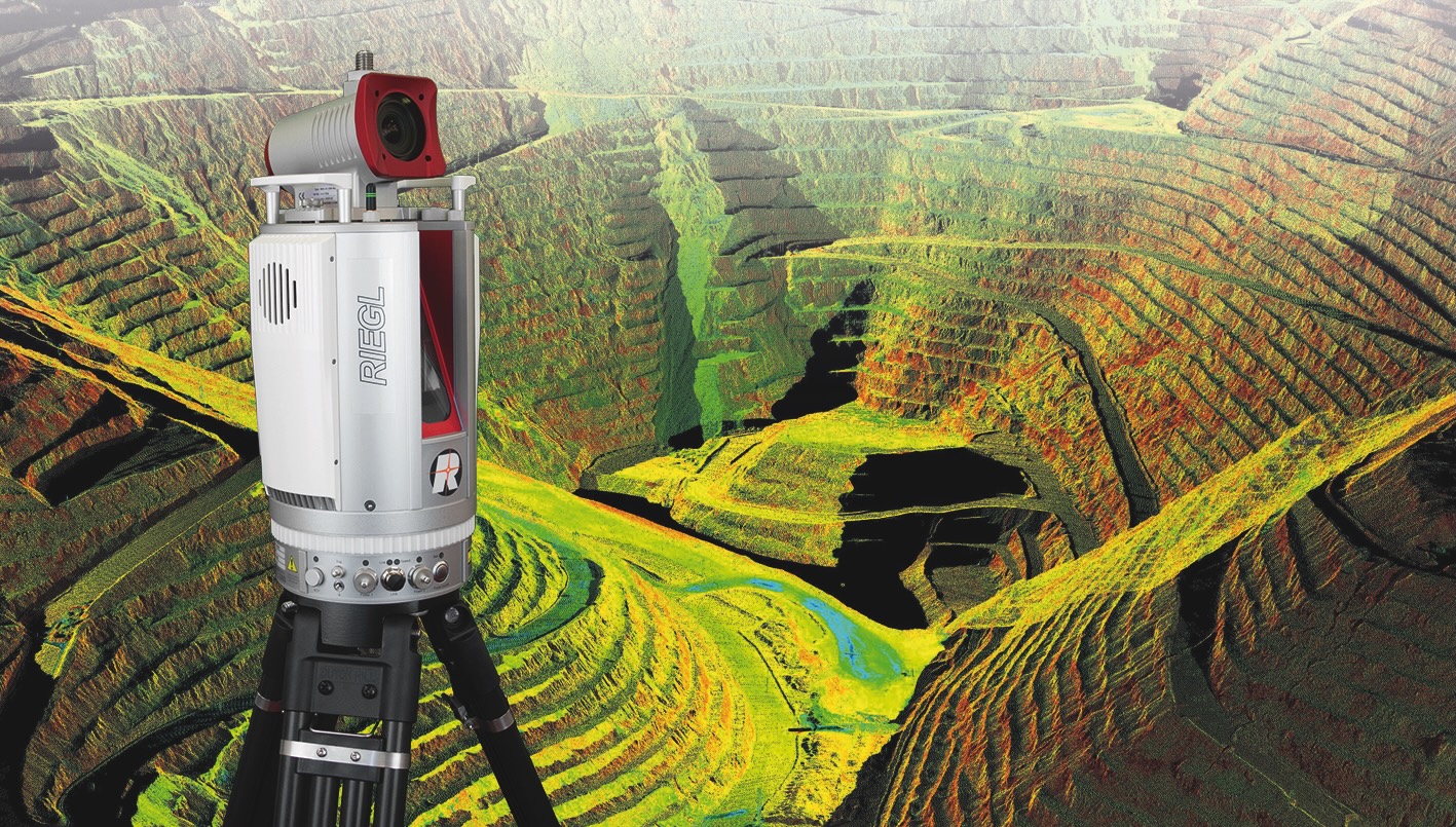
Among the actors contributing to Geo Week’s technical dimension is RIEGL, whose engineering team has long emphasized a data-driven approach to LiDAR evaluation. At booth 1103, the company provides hands-on exposure to airborne, UAV-based, mobile and topo-bathymetric configurations. Rather than focusing on catalog features, the demonstrations highlight trajectory computation, waveform digitization, point cloud calibration and quality assurance (QA/QC).
RIEGL’s specialists support the technical discussion with both institutional expertise and named contributions. Technical representatives including Philipp Amon and Peter Rieger participate in presentations addressing corridor mapping strategies, GNSS/INS integration and UAV applications. Their interventions align well with Geo Week’s emphasis on workflow maturity and data interoperability. Over the years, both engineers have been active in the dissemination of LiDAR methodologies, focusing not only on instrumentation but also on modeling, processing and system integration.
Workflow, Accuracy and Deliverables
The notion of workflow is central to LiDAR evaluation. Precision metrics alone do not determine whether a dataset is usable for engineering, monitoring or design purposes. Surveying workflows demand reproducibility, traceability and interoperability across software ecosystems. The technical sessions at Geo Week underscore several workflow components:
— Trajectory and inertial integration, critical for airborne and mobile platforms.
— Calibration and boresight alignment, enabling consistent multi-sensor geometry.
— Classification and filtering, supporting the extraction of terrain, vegetation and infrastructure features.
— Quality control metrics, including strip adjustment, positional accuracy verification and residual analysis.
— Data standardization, typically through LAS/LAZ and associated metadata.
— Integration with CAD/BIM/GIS, necessary for deliverables in engineering and infrastructure management.
These stages increasingly influence procurement decisions in public agencies and utilities, where deliverables form part of long-term asset records rather than isolated survey campaigns.
Sectoral Drivers and Frequency Requirements
Multiple sectors now request LiDAR data at update frequencies that surpass historical photogrammetric cycles. Corridors such as railways, highways and energy transmission networks require recurrent updates to monitor encroachments, structural changes and vegetation dynamics. Urban environments require detailed and frequently updated 3D models to support planning, simulation and digital twin initiatives. Environmental and coastal applications use LiDAR as a quantitative tool for erosion analysis, flood modeling and wetland studies.
These demands place pressure on acquisition and processing cycles. UAV-based LiDAR, for instance, enhances repeatability through ease of deployment, while airborne LiDAR provides wide-area consistency. Topo-bathymetric systems extend monitoring to transitional environments at the land–water interface, where change detection is particularly valuable. Mobile mapping platforms contribute structural and surface detail essential for digital twin applications.
Why Live Demonstrations Matter
Surveying professionals benefit from live testing because it allows them to evaluate platform integration, operational complexity and data outputs within a controlled window. Discussions with technical teams help clarify aspects not readily evident from specifications: noise behavior on dark surfaces, accuracy under canopy, intensity uniformity, waveform recoverability, processing times and classification artifacts. For UAV platforms, battery endurance, payload distribution and regulatory compliance emerge as key considerations.
The presence of industry actors such as RIEGL supports this mode of evaluation by bridging instrumentation and methodology. Technical contributors can articulate not only how a sensor performs, but under what operating conditions performance is optimized or degraded. This level of transparency encourages more informed decisions for surveying agencies, engineering firms and research institutions.
A Convergence of Methods and Disciplines
Geo Week’s role within the surveying domain reflects an ongoing convergence between mapping, monitoring and modeling. LiDAR is no longer viewed solely as a data acquisition instrument; it is integrated into digital twin pipelines, simulation environments, construction verification and asset management systems. This multidisciplinary convergence requires that professionals understand not only sensor capabilities but also data semantics and interoperability standards.
Conclusion
Geo Week 2026 demonstrates how the evaluation of LiDAR systems has moved beyond the catalog and into the realm of technical workflows and hands-on testing. Live demonstrations, supported by engineering teams including RIEGL’s specialists, provide surveying professionals with an environment in which platform typologies, processing strategies and application requirements can be examined holistically. For a sector increasingly defined by data maturity and interoperability, such evaluations contribute to a more rigorous and informed adoption of laser scanning technologies.
