
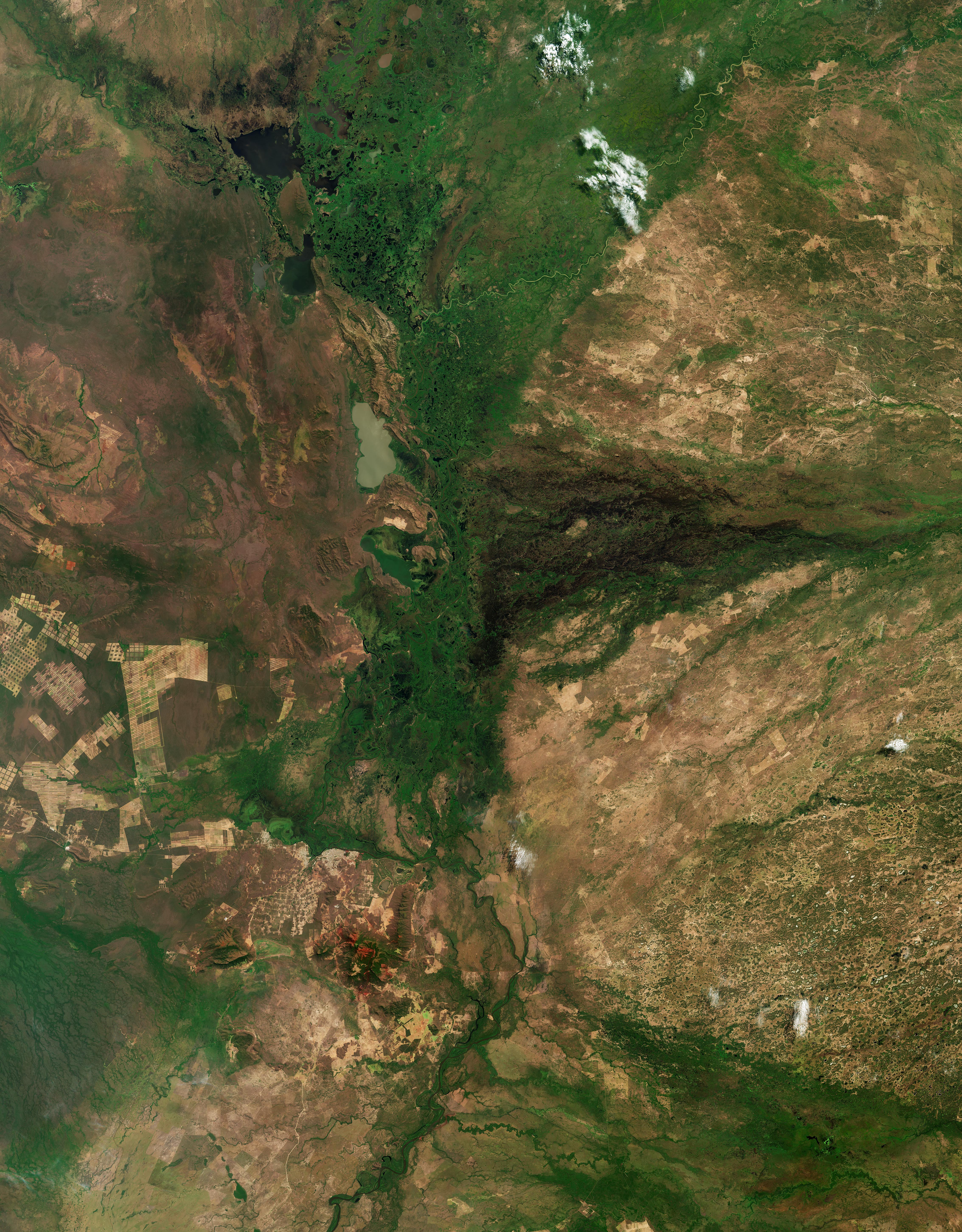
La missione Copernicus Sentinel-2 ci porta al confine brasiliano-boliviano su una parte della regione del Pantanal, un ecosistema unico che ospita una notevole varietà di piante e fauna selvatica.
Coprendo un'area fino a 200.000 km², il Pantanal è la più grande pianura alluvionale al mondo ed una zona umida di importanza internazionale. Si trova principalmente all’interno degli stati brasiliani di Mato Grosso e Mato Grosso do Sul, ma si estende anche in Bolivia e Paraguay. Una parte del Pantanal è protetta come Parco Nazionale del Pantanal Matogrossense, che mira a garantire la ricca biodiversità e la cura degli ecosistemi della regione: essa è parzialmente visibile nella parte superiore dell'immagine.
Questa immagine risalente a settembre 2025 cattura una piccola frazione del Pantanal, che si estende sul confine tra la Bolivia ad ovest e gli stati brasiliani del Mato Grosso a nord e Mato Grosso do Sul ad est. Nell'immagine è visibile un complesso mosaico di praterie inondate, savane, foreste tropicali, fiumi ed insediamenti umani.
Il corridoio verde scuro che taglia verticalmente il centro è una fitta vegetazione 'riparia' – che si trova lungo i canali delle pianure alluvionali e le zone umide permanenti. Al contrario, le savane circostanti sono visibili di colore marrone.
Il Pantanal si configura come un enorme delta interno, dove confluiscono diversi fiumi, alimentando la vasta rete di zone umide. Il Rio Paraguay, che si vede serpeggiare attraverso la fascia verde e rigogliosa, è il fiume più importante del Pantanal, poichè il suo ciclo naturale di piena crea l'ambiente unico della regione e sostiene la sua fauna diversificata.
Il lago color latte vicino al centro dell'immagine è la Laguna Mandioré. Condiviso tra Brasile e Bolivia, è un lago poco profondo alimentato da inondazioni stagionali.
Seguendo il letto del fiume verso sud possiamo vedere alcune strutture urbane. La più grande ad ovest è la città brasiliana di Corumbá, che fa da porta d'accesso al Pantanal. La sua griglia rettangolare è circondata a sud da un mosaico di campi e pascoli color marrone.
Le aree bruno-rossastre sono distese di terreno argilloso crepato, che vengono esposte durante la stagione secca. Queste aree, aride a settembre quando questa immagine è stata acquisita, diventano verdi durante la stagione delle piogge da novembre ad aprile.
Le due conurbazioni visibili ad ovest di Corumbá sono i porti interni di Puerto Suárez e Puerto Quijarro, sul lato boliviano del confine. Le macchie marrone chiaro a sinistra rappresentano savana e foreste disboscate per pascoli ed allevamenti per bestiame. Le strisce sottili di terra sono molto probabilmente campi coltivati a soia. Questa regione ha subito una significativa deforestazione negli ultimi anni, con alcune aree trasformate da fitta foresta a mosaico di campi.
Scarica immagine Hi-Res (5,11 MB - .JPG)
Scarica immagine Hi-Res (470,58 MB - .TIF)
---
Pantanal
The Copernicus Sentinel-2 mission takes us at the Brazilian-Bolivian border over part of the Pantanal region, a unique ecosystem, home to an impressive variety of plants and wildlife.
Covering an area of up to 200 000 sq km, the Pantanal is the largest floodplain in the world and a wetland of international importance. It is mainly located within the Brazilian states of Mato Grosso and Mato Grosso do Sul, but it also extends into Bolivia and Paraguay. A portion of the Pantanal is protected as the Pantanal Matogrossense National Park, which aims to ensure the maintenance of the region’s ecosystems and rich biodiversity and is partly visible in the upper portion of the image.
This image from September 2025 captures a small fraction of the Pantanal, which straddles the border between Bolivia to the west, and the Brazilian states of Mato Grosso to the north and Mato Grosso do Sul to the east. A complex mosaic of flooded grasslands, savannas, tropical forests, rivers and human settlements are visible in the image.
The dark green corridor slicing vertically through the centre is dense, ‘riparian’ vegetation – which is found along the floodplain channels and permanent wetlands. In contrast, the surrounding savannas are visible in brown.
The Pantanal acts as an enormous internal delta, where several rivers merge, feeding the vast network of wetlands. The Rio Paraguay, seen meandering across the green lush band, is the most important river in Pantanal as its natural flood cycle creates the region's unique environment and supports its diverse fauna.
The milky-colour lake near the centre of the image is the Laguna Mandioré. Shared between Brazil and Bolivia, it is a shallow lake fed by seasonal floods.
Following the riverbed southwards, we can see some urban structures. The largest to the west is the Brazilian city of Corumbá, which serves as a gateway to Pantanal. Its rectangular grid is surrounded to the south by a patchwork of fields and brownish pastures.
The reddish-brown areas are expanses of cracked clay soil, which are exposed during the dry season. These areas, barren in September when this image was acquired, become green during the wet season from November to April.
The two conurbations visible west of Corumbá are the inland ports of Puerto Suarez and Puerto Quijarro, on the Bolivian side of the border. The light brown patches on the left represent savanna and forest cleared for cattle pastures and ranches. The thin strips of land are most likely cultivated soybean fields.
This region has undergone significant deforestation in recent years, with some areas transformed from dense forest into a mosaic of fields.
[Credits: contains modified Copernicus Sentinel data (2025), processed by ESA - Translation: Gianluca Pititto]
