
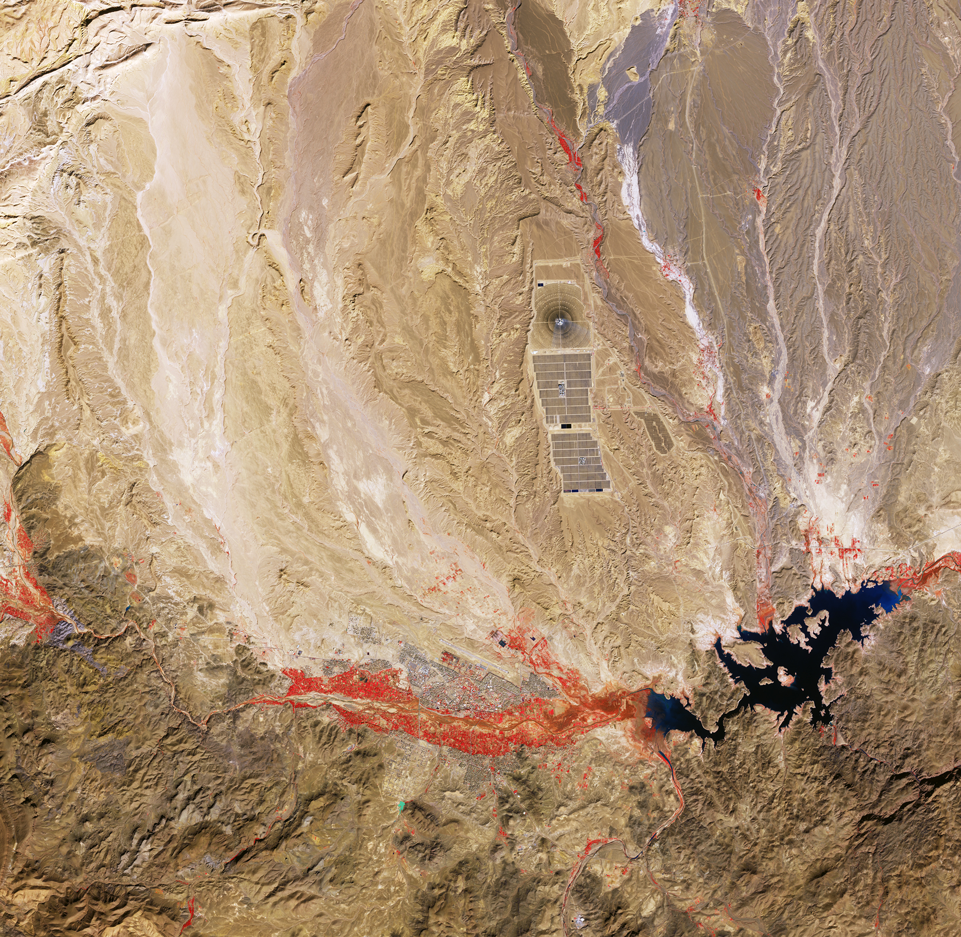
La missione Copernicus Sentinel-2 ci porta sul territorio del Marocco centro-meridionale, vicino alla città di Ouarzazate.
L'immagine cattura la regione dei Monti Anti-Atlante, parzialmente visibile a sud, le cui cime corrono parallele ed a sud della catena centrale dell'Alto Atlante del Nord Africa. Qui il paesaggio è principalmente arido e desolato, poiché queste montagne si trovano all'interno della zona climatica sahariana.
Questa immagine a falsi colori è stata elaborata utilizzando il canale nel vicino infrarosso di Sentinel-2. Questa combinazione di bande è la più frequentemente utilizzata per valutare la densità e la salute della vegetazione, poiché le piante riflettono la radiazione nel vicino infrarosso e nel verde, mentre assorbono il rosso. Poiché le piante riflettono più nel vicino infrarosso che nel verde, il terreno densamente vegetato appare di un rosso acceso.
Aree vegetate di color rosso sono chiaramente visibili lungo le rive dei fiumi che attraversano il terreno semi-arido circostante. I fiumi della regione sono per lo più stagionali, trasportando tipicamente quantità significative di acqua solo durante l'inverno e la primavera. Ripresa nel gennaio 2026, durante la stagione delle piogge, questa immagine mostra anche chiaramente gli affluenti più piccoli, insieme a vegetazione ed appezzamenti agricoli.
A nord della più ampia area rossa si trova il tessuto urbano di Ouarzazate, capoluogo provinciale, situato nella valle del fiume Ouarzazate, noto anche come Assif n'Tidili. Grazie ai suoi paesaggi desertici e all'architettura storica, la città di lingua berbera è una location popolare per le riprese. Qui sono state girate produzioni come Lawrence d'Arabia (1962), L'ultima tentazione di Cristo (1988), La mummia (1999), Il Gladiatore (2000) e parte della serie TV Game of Thrones.
A pochi chilometri ad est della città si trova il bacino idrico El Mansour Eddahbi, visibile in nero. Il lago ha una profondità media di 30 m ed è diviso in due sezioni: una parte occidentale più piccola alimentata dal fiume Ouarzazate e da diversi corsi d'acqua minori ed una sezione orientale molto più ampia alimentata dal Draa – il fiume più lungo del Marocco – visibile in basso a destra, che scorre in direzione sud-est dal bacino.
La grande struttura che sorge a circa 10 km a nord della città è la centrale solare di Ouarzazate, chiamata anche centrale Noor (luce, in arabo). Completato in quattro fasi e con una superficie di oltre 3000 ettari, si tratta del più grande impianto solare concentrato al mondo. Questi impianti utilizzano specchi per focalizzare la luce solare sui ricevitori, generando calore che può essere immagazzinato e convertito in elettricità anche quando il sole non splende.
Scarica immagine Hi-Res (1,45 MB - .JPG)
Scarica immagine Hi-Res (41,90 MB - .TIF)
---
Ouarzazate, Morocco
The Copernicus Sentinel-2 mission takes us over south-central Morocco, near the city of Ouarzazate.
This image captures the region of the Anti-Atlas Mountains, partially visible to the south, which run parallel to and south of the central range of North Africa’s High Atlas mountains. Here the landscape is mostly dry and barren, as these mountains lie within the Saharan climate zone.
This false-colour image has been processed using Sentinel-2’s near-infrared channel. This band combination is most commonly used to assess vegetation density and health, as plants reflect near-infrared and green light while absorbing red. Since plants reflect more near-infrared than green, densely vegetated land appears bright red.
Red vegetated areas are clearly visible along the banks of the rivers that flow through the surrounding semi-arid terrain. Rivers in the region are mostly seasonal, typically only carrying significant amounts of water during the winter and spring. Captured in January 2026, during the wet season, this image even clearly shows smaller tributaries, along with vegetation and agricultural plots.
North of the larger red area, lies the urban fabric of Ouarzazate, the provincial capital, situated in the valley of the Ouarzazate River, also known as Assif n'Tidili. Owing to its desert landscapes and historical architecture, the Berber-speaking city is a popular filming location. Productions such as Lawrence of Arabia (1962), The Last Temptation of Christ (1988), The Mummy (1999), Gladiator (2000) and part of the TV series Game of Thrones were shot here.
Just a few kilometres east of the city lies El Mansour Eddahbi Reservoir, visible in black. The lake has an average depth of 30 m and is divided into two sections: a smaller western part fed by the Ouarzazate River and several smaller streams, and a much larger eastern section fed by the Draa – Morocco’s longest river – seen in the lower right flowing southeast from the reservoir.
The large feature about 10 km north of the city is the Ouarzazate solar power station, also called Noor (Arabic for light) Power Station. Completed in four phases and covering over 3000 hectares, it is the world's largest concentrated solar power facility. Such plants use mirrors to focus sunlight onto receivers, generating heat that can be stored and converted into electricity even when the sun is not shining.
[Credits: contains modified Copernicus Sentinel data (2026), processed by ESA - Translation: Gianluca Pititto]
