
La missione Copernicus Sentinel-2 ha catturato una spettacolare meraviglia geologica nel deserto del Sahara, in Mauritania: la Struttura di Richat.
Questa gigantesca struttura morfologica si affaccia da un mare di sabbia dorata nella regione di Adrar, nel nord della Mauritania. Un tempo si pensava fosse il sito di un impatto meteoritico, ma ora si ritiene che la Struttura di Richat sia stata causata da un processo di sollevamento di una grande cupola di roccia fusa che, una volta in superficie, sia stata modellata dall'erosione di vento, sabbia e acqua. I geologi concordano sul fatto che la struttura abbia almeno 100 milioni di anni.
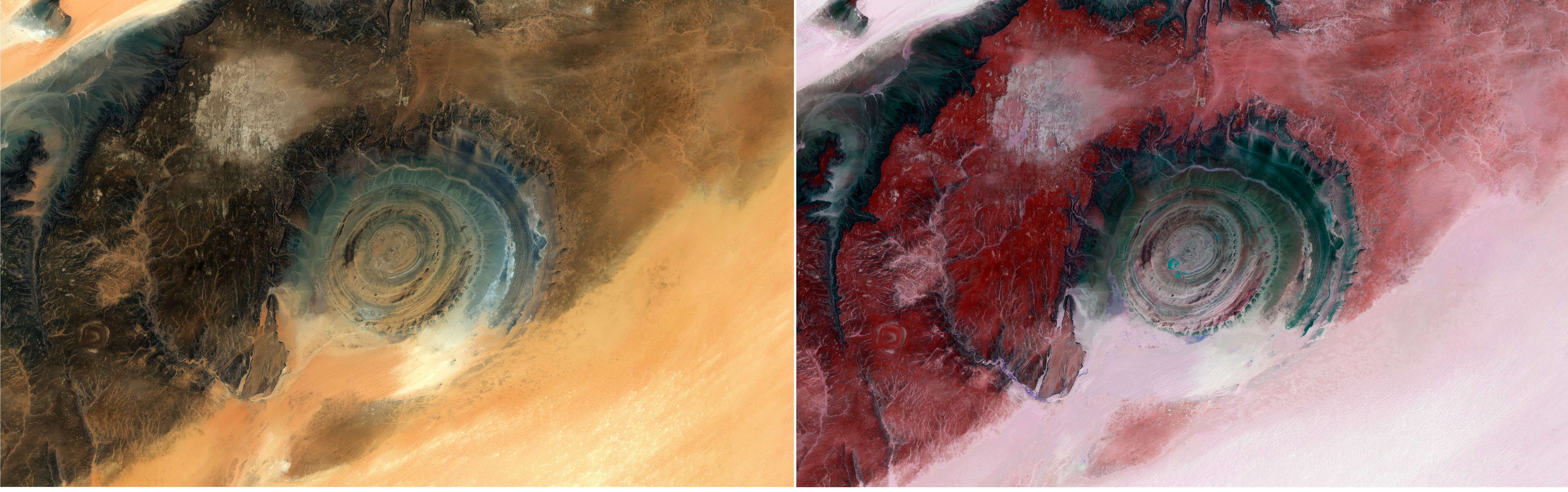
La formazione stratificata è composta da una serie di anelli concentrici e ricorda un ‘occhio di bue’ visto dallo spazio, quindi è conosciuta anche come occhio del Sahara o occhio dell'Africa.
La Struttura di Richat, che presenta un diametro di 50 km, è più facile da osservare dallo spazio che da terra ed è stata un punto di riferimento familiare per gli astronauti fin dalle prime missioni con equipaggio.
In questo confronto possiamo vedere due vedute acquisite nel mese di settembre 2025: l'immagine a sinistra è a colori naturali, mentre quella a destra è una combinazione di falsi colori che evidenzia caratteristiche particolari.
Questa straordinaria formazione mostra strati di roccia sedimentaria in diverse zone a seconda dei tassi di erosione dei vari tipi di roccia. Questa caratteristica si può apprezzare meglio nell'immagine in falsi colori. Le arenarie di quarzite, più resistenti all'erosione, appaiono in tonalità di rosso e rosa e formano gli anelli esterni e le alte creste interne, con valli di roccia meno resistente presenti tra di essi e visibili come aree più scure. Gli anelli centrali dell'occhio sono alti circa 80 m, con rocce più antiche di quelle che formano gli anelli più esterni.
Nell'immagine a sinistra l'area scura che circonda l'occhio fa parte dell'altopiano di roccia sedimentaria dell'Adrar, che si erge circa 200 m sopra le sabbie desertiche circostanti, le quali a loro volta fanno parte dell'Erg Ouarane, un'immensa distesa sabbiosa che si estende per centinaia di chilometri verso il Mali.
La sabbia è anche chiaramente visibile nel suo avanzare sul lato sud della struttura. Qui si possono riconoscere alberi e cespugli individuali come minuscoli puntini, visibili in viola nell'immagine a falsi colori, i quali seguono la struttura del letto di un fiume prosciugato.
Scarica immagine1 Hi-Res-JPG (6,63 MB)
Scarica immagine1 Hi-Res-TIF (428,50 MB)
Scarica immagine2 Hi-Res-JPG (6,54 MB)
Scarica immagine2 Hi-Res-TIF (613,12 MB)
---
Eye of the Sahara
The Copernicus Sentinel-2 mission captures a spectacular geological wonder in the Sahara Desert of Mauritania: the Richat Structure.
This giant feature looks out from a sea of golden sand in the Adrar Region of northern Mauritania. Once thought to be the site of a meteor impact, the Richat Structure is now believed to have been caused by a process of uplift of a large dome of molten rock that, once at the surface, was shaped by wind, sand and water erosion. Geologists agree that the structure is at least 100 million years old.
The layered formation consists of a series of concentric rings and resembles a bull’s eye from space, so is also known as the eye of the Sahara or the eye of Africa.
The Richat Structure, 50 km in diameter, is easier to observe from space than from the ground, and has been a familiar landmark for astronauts since the earliest manned missions.
In this comparison, we can see two views captured in September 2025: the image on the left is in natural colour, while the image on the right is a false-colour combination which highlights specific features.
This remarkable formation exposes layers of sedimentary rock in different places, depending on the rates of erosion on the varying rock types. This can be better appreciated in the false-colour image. The more erosion-resistant quartzite sandstones appear in shades of red and pink and form the outer rings and high ridges internally, with valleys of less-resistant rock between them visible as darker areas. The central rings of the eye are about 80 m tall, with rocks older than those forming the outer rings.
In the image on the left the dark area surrounding the eye is part of the Adrar plateau of sedimentary rock standing some 200 m above the surrounding desert sands, which in turn are part of the Erg Ouarane, an immense sand expanse stretching hundreds of kilometres to Mali.
Sand is also clearly visible encroaching into the structure’s southern side. Here, individual trees and bushes can be spotted as tiny dots, which are visible in purple in the false-colour image, following a dry riverbed structure.
[Credits: contains modified Copernicus Sentinel data (2025), processed by ESA - Translation: Gianluca Pititto]
