
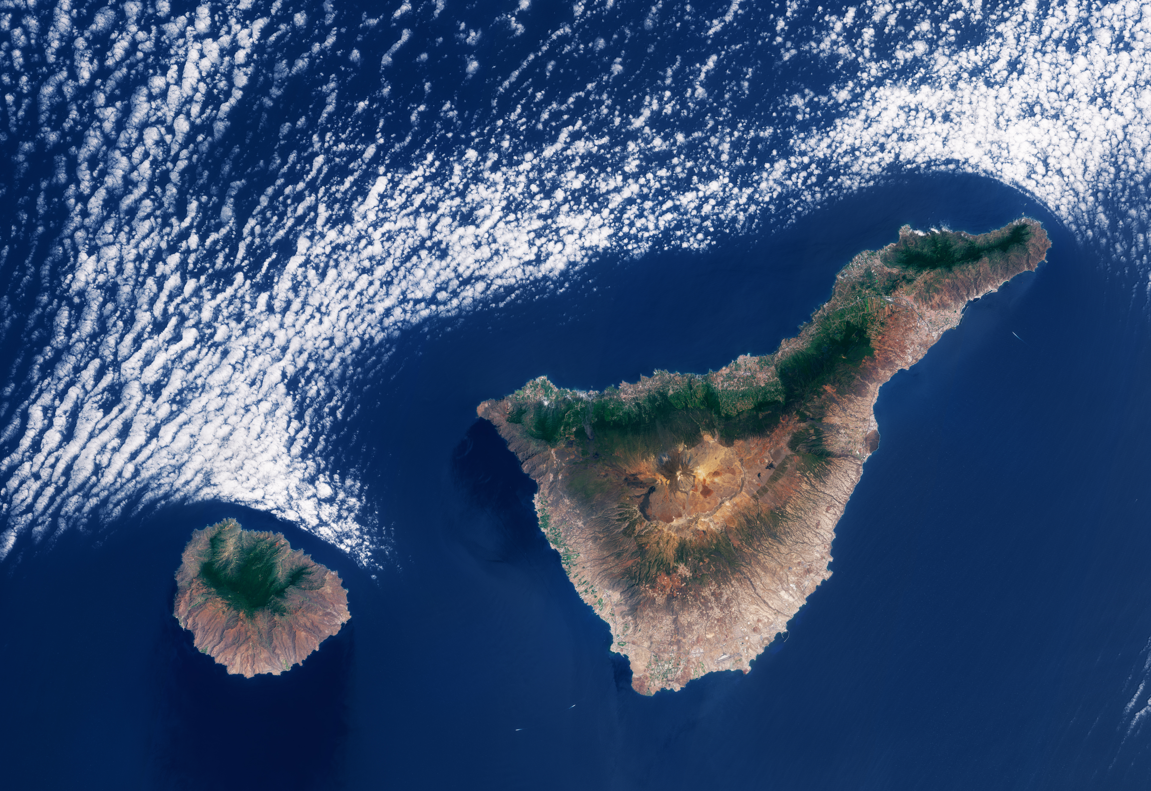
Questa immagine acquisita da Copernicus Sentinel-2 mette in evidenza una caratteristica formazione nuvolosa a nord delle Isole Canarie di Tenerife e di La Gomera.
Formatesi da attività vulcanica milioni di anni fa, le Isole Canarie costituiscono la regione più meridionale della Spagna. Si trovano nell'Oceano Atlantico settentrionale, a circa 100 km dalla costa africana. L'arcipelago è composto da sette isole più grandi - tra cui La Gomera e Tenerife - e numerose isole più piccole ed isolotti.
La Gomera, visibile a sinistra, ha una forma approssimativamente circolare, con coste impervie e un interno montuoso. Il suo punto più alto, il Picco Garajonay, si trova al centro dell'isola, circondato dalla vegetazione rigogliosa e diversificata del Parco Nazionale di Garajonay. Il principale porto e capitale dell'isola è San Sebastián de la Gomera, sulla costa orientale, di fronte all'isola di Tenerife.
Tenerife invece è la più grande delle Canarie. È dominata dal vulcano El Teide, la montagna più alta del territorio spagnolo, che si eleva fino a circa 3718 m. Sono visibili aree urbane lungo la costa. Ad esempio, la capitale Santa Cruz de Tenerife sorge nella parte nord-orientale dell'isola, la città portuale di Puerto de la Cruz si trova sul lato nord e l'aeroporto di Tenerife Sud sulla costa meridionale.
Grazie alla loro topografia diversificata ed ai fattori climatici unici, entrambe le isole sperimentano molteplici microclimi. Ciò significa che il clima può variare significativamente attraverso ciascuna isola, permettendo spiagge calde e soleggiate a sud, aree verdi più umide a nord e condizioni fresche o addirittura nevose ad alta quota: il tutto entro una breve distanza.
Il meteo ed il clima sono fortemente influenzati dai venti alisei, che soffiano da nord-est per la maggior parte dell'anno, portando umidità e precipitazioni a nord dell'isola. Questo effetto si può apprezzare nell'immagine grazie al netto contrasto, in entrambe le isole, tra il nord generalmente più verde e la parte meridionale più arida.
L'interazione tra i venti e la scoscesa topografia delle isole è anche responsabile dei modelli nuvolosi che solitamente si formano sopra ed intorno all'arcipelago. In questa immagine, si possono vedere nuvole stratocumulo marine, che seguono strettamente le coste settentrionali delle isole. Quando i venti alisei soffiano da nord-est spingono l'aria marina fresca e umida verso le isole. Le condizioni atmosferiche della regione intrappolano l'aria ad altitudini inferiori a 1500 m, formando la copertura stratocumulo. Quando le gocce nelle nuvole entrano in contatto con la superficie terrestre più calda, evaporano approssimativamente seguendo i contorni delle coste.
Scarica immagine Hi-Res (8,23 KB - .JPG)
Scarica immagine Hi-Res (135,29 MB - .TIF)
---
Cloud patterns over the Canary Islands
This Copernicus Sentinel-2 image highlights a distinctive cloud formation north of the Canary Islands of Tenerife and La Gomera.
Formed by volcanic activity millions of years ago, the Canary Islands are the southernmost region of Spain. They are located in the North Atlantic Ocean, around 100 km off the coast of Africa. The archipelago consists of seven larger islands, including La Gomera and Tenerife, and numerous smaller islands and islets.
La Gomera, visible on the left, has a roughly circular shape with rugged coasts and a mountainous interior. Its highest point, Garajonay Peak, is in the centre of the island, surrounded by the lush and diverse vegetation of the Garajonay National Park. The island’s chief port and capital is San Sebastián de la Gomera, on the east coast, facing the island of Tenerife.
Tenerife is the largest of the Canaries. It is dominated by the El Teide volcano, the highest mountain on Spanish territory, standing at around 3718 m. Built-up areas are visible around the coastline. For instance, the capital city of Santa Cruz de Tenerife is on the northeastern part of the island, the harbour city of Puerto de la Cruz is on the north side and Tenerife South Airport is on the southern coast.
Owing to their diverse topography and unique climatic factors, both islands experience multiple microclimates. This means that the weather can vary significantly across each island, allowing for warm, sunny beaches in the south, wetter green areas in the north, and cool or even snowy conditions at high-altitude, all within a short distance.
Weather and climate are heavily influenced by the trade winds blowing from the northeast for most of the year, bringing humidity and precipitation to the north of the island. This effect can be appreciated in the image through the sharp contrast between the generally greener north and the more arid southern part on both islands.
The interaction between the winds and the islands’ steep topography is also responsible for the cloud patterns that usually form over and around the archipelago. In this image, marine stratocumulus clouds can be seen closely following the northern coasts of the islands.
As the trade winds blow from the northeast, they push the cool, moist marine air towards the islands. Atmospheric conditions in the region trap the air at altitudes below 1500 m, forming the stratocumulus cover. When the droplets in the clouds come into contact with the warmer land surface, they evaporate roughly following the outlines of the coasts.
[Credits: contains modified Copernicus Sentinel data (2025), processed by ESA - Translation: Gianluca Pititto]
