
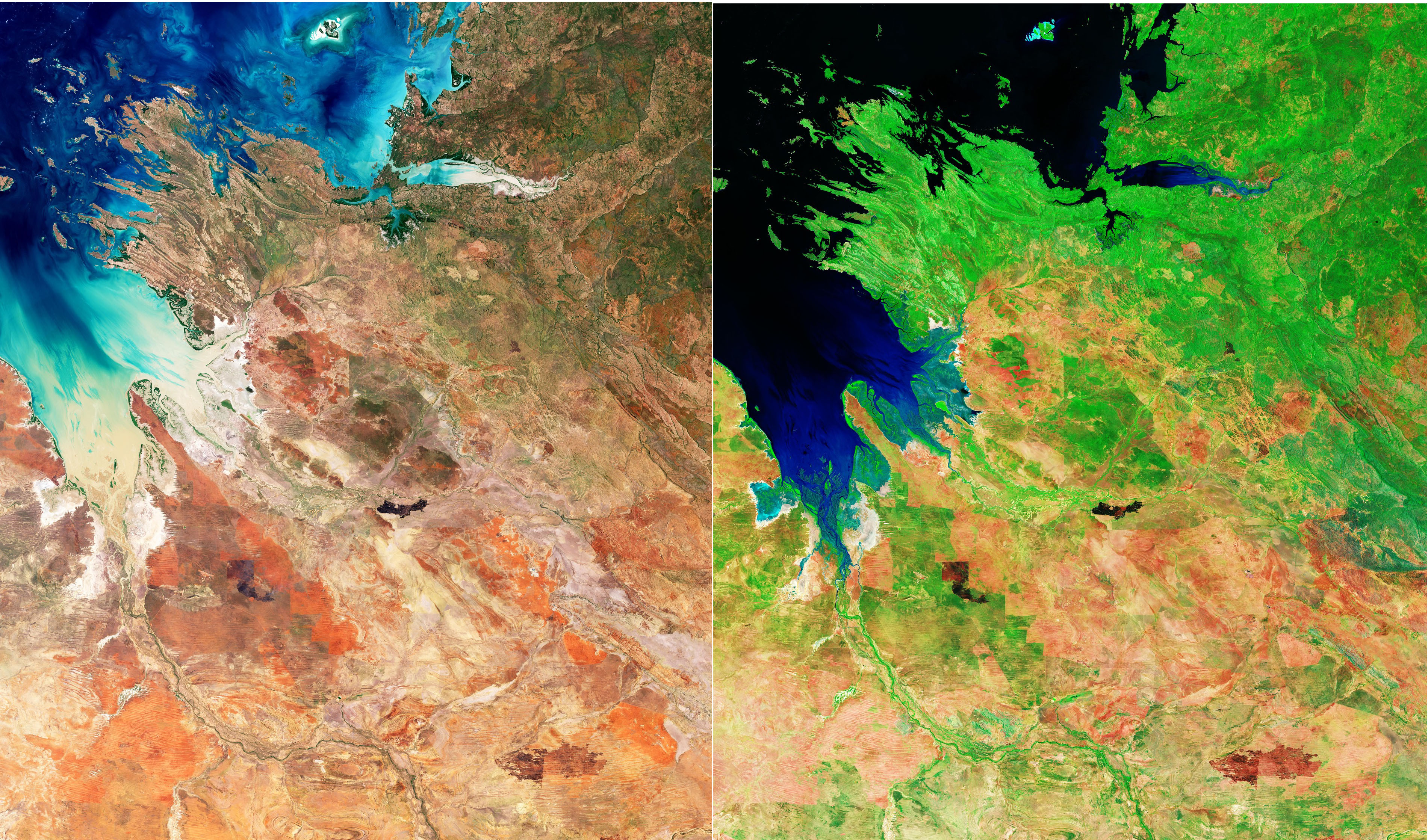
La regione del Kimberley, in Australia Occidentale, è mostrata in questa duplice vista ottenuta dalla missione Copernicus Sentinel-2.
L'area raffigurata fa parte della costa occidentale del Kimberley lungo l'Oceano Indiano. La grande insenatura a sinistra è King Sound, un golfo lungo circa 120 km e largo 50 km. King Sound ha le maree più alte d'Australia e tra le più alte al mondo, raggiungendo un intervallo massimo di circa 11-12 m.
Diversi fiumi riversano nell’insenatura le loro acque fangose e cariche di sedimenti. Tra questi il fiume Fitzroy - che scorre dal centro inferiore dell'immagine - è uno dei corsi d'acqua più grandi d'Australia. La città portuale di Derby si trova vicino alla foce di questo fiume, sulla riva occidentale della penisola più piccola, la quale si protende nell’ insenatura.
Acquisite nel dicembre 2025, queste due viste utilizzano diverse combinazioni delle bande spettrali di Sentinel-2: l'immagine a sinistra è a colori naturali - come l'occhio umano vedrebbe l'area - mentre l'immagine a destra è stata elaborata in falsi colori, allo scopo di evidenziare caratteristiche specifiche.
Una miriade di estuari di mangrovie sono sparsi lungo la costa, che nell'immagine a sinistra sono parzialmente nascosti tra le vaste distese fangose mareali. La vista in falsi colori permette di distinguere facilmente le mangrovie, le quali ora appaiono di colore verde-neon, circostanza che indica quanto risultino dense e vitali le foreste di mangrovie. Questo è particolarmente importante, giacchè le mangrovie apportano molti benefici ambientali agli ecosistemi costieri e di estuario, proteggendo inoltre la costa dall'erosione.
A causa della presenza di sedimenti trasportati dal riversamento fluviale, l'acqua nel King Sound appare di tonalità marrone, suggerendo anche acque poco profonde. In falsi colori l'acqua appare in tonalità di nero e blu, circostanza che evidenzia acque profonde, con il blu indicando una maggiore concentrazione di sedimenti sulla superficie.
L'entroterra visibile nelle immagini è una zona di transizione dove le praterie lasciano gradualmente il posto ai deserti aridi che si trovano più a sud, nel vasto e remoto interno australiano. Nei colori naturali il paesaggio è dominato da una rada vegetazione verde e dal profondo ocra e rosso ruggine del suolo – questo è noto come ‘suolo pindano’, ricco di ossidi di ferro e tipicamente presente nella regione sud-occidentale del Kimberley.
In questa vista il rosso naturale del terreno può talvolta nascondere le cicatrici da surriscaldamento, mentre nell'immagine in falsi colori esse risultano chiaramente visibili come macchie scure sul terreno. La capacità di identificare le aree bruciate dagli incendi boschivi è una risorsa preziosa in regioni come queste - soggette ad incendi – in quanto consente alle autorità di monitorare meglio la frequenza degli incendi, mappare l'estensione delle aree bruciate e valutare l'impatto sull'ambiente circostante.
Scarica immagine1 Hi-Res (5,44 MB - .JPG)
Scarica immagine1 Hi-Res (474,44 MB - .TIF)
Scarica immagine2 Hi-Res (5,72 MB - .JPG)
Scarica immagine2 Hi-Res (474,44 MB - .TIF)
---
Kimberley, Australia
Western Australia’s Kimberley region is featured in this double view from the Copernicus Sentinel-2 mission.
The area pictured is part of Kimberley’s western coastline along the Indian Ocean. The large inlet on the left is King Sound – a gulf measuring about 120 km long and 50 km wide. King Sound has the highest tides in Australia, and amongst the highest in the world, reaching a maximum range of around 11 to 12 m.
Several rivers empty their muddy and sediment-laden waters into the sound. Among these, the Fitzroy River, flowing from the bottom centre of the image, is one of Australia’s largest watercourses. The port town of Derby lies near the mouth of this river on the western shore of the smaller peninsula jutting out into the sound.
Acquired in December 2025, these two views use different combinations of Sentinel-2’s spectral bands: the image on the left is in natural colour, as the human eye would see the area, while the image on the right has been processed in false colour to highlight specific features.
A myriad of mangrove estuaries are scattered around the coast, which in the left-hand image are partially concealed within the large expanses of tidal mud flats. The false-colour view allows the mangroves to be easily distinguished as they appear in neon green, which indicates how dense and vital the mangrove forests are. This is particularly important, as mangroves contribute many environmental benefits to coastal and estuary ecosystems and protect the coastline from erosion.
Owing to the presence of sediment carried by river discharge, the water in King Sound appears brownish in the left image, also suggesting shallow water. In false colours, the water shows up in black and blue hues, which reveal deep water with blue denoting a higher concentration of sediment on the surface.
The hinterland visible in the images is a transition zone where grasslands gradually give way to the arid deserts further south in Australia’s vast and remote interior. In natural colours, the landscape is dominated by sparse green vegetation and the deep ochre and rusty red of the soil – this is known as pindan soil, which is rich in iron oxides and is typically found in the south-western Kimberley region.
In this view, the natural red of the soil can sometimes hide burn scars, while in the false-colour image they are clearly visible as dark patches on the land. The ability to identify areas burnt by wildfires is a valuable resource in regions such as this one, prone to fires, as it allows authorities to better track the frequency of fires, map the extent of the burned areas and evaluate the impact on the surrounding environment.
[Credits: contains modified Copernicus Sentinel data (2025), processed by ESA - Translation: Gianluca Pititto]
