
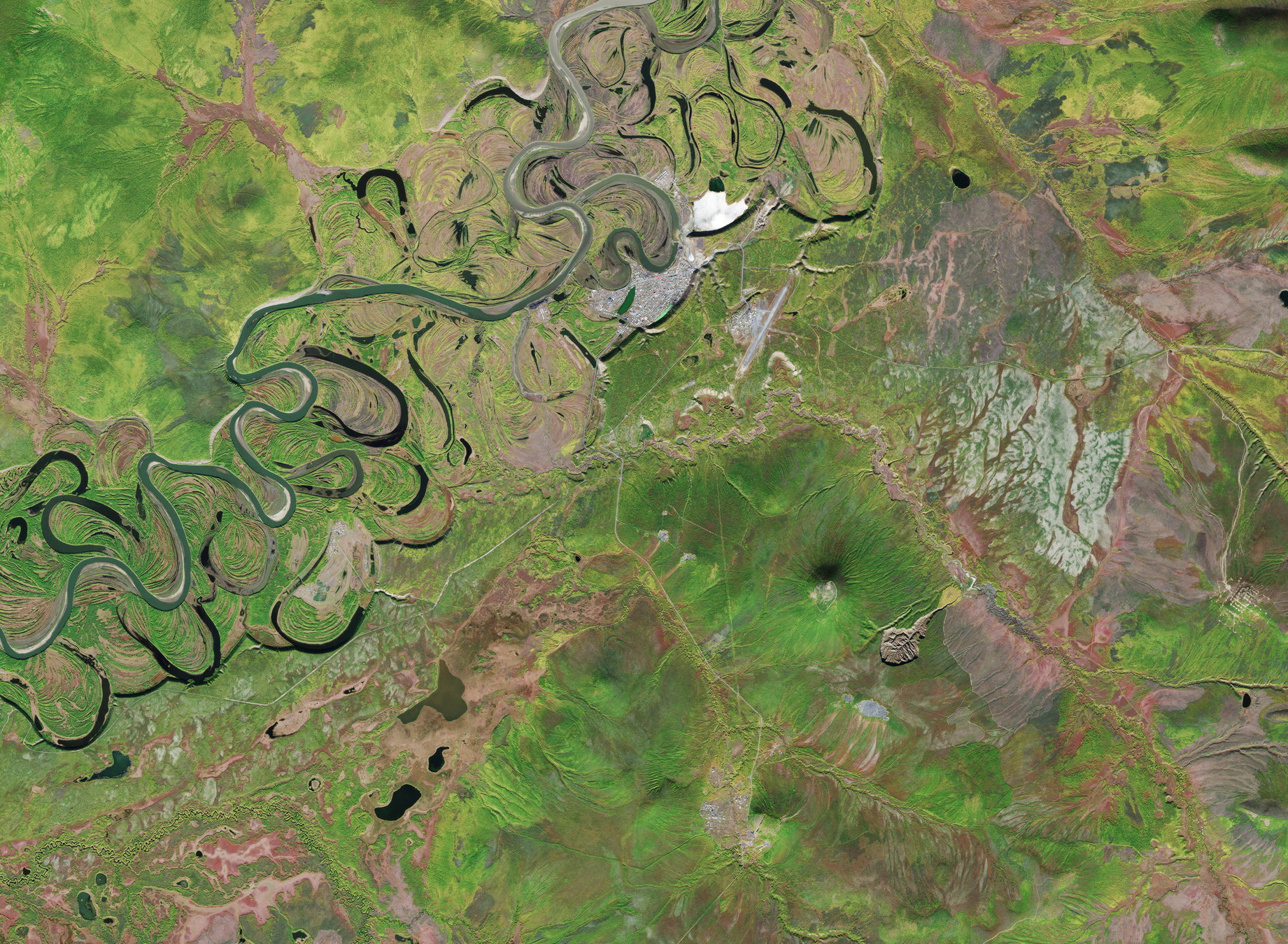
Questa immagine del satellite Copernicus Sentinel-2 mostra il cratere di Batagaika, in Siberia. Si tratta del più grande cratere di permafrost al mondo, causato dallo scioglimento del permafrost e noto anche come 'mega-slump' (nota trad.: crollo gigante).
Dall'alto il terreno collassato ricorda un girino o una razza, con 'pinne' quasi simmetriche ed una 'coda' rivolta verso nord-est. Il cratere – visibile nel lato in basso a destra dell'immagine – è profondo circa 100 m e lungo 1 km, ma sta crescendo ad un ritmo di circa 30 m all'anno. Secondo gli scienziati questa rapida espansione è iniziata qualche decennio fa ed è causata dalla deforestazione e dalle temperature più calde. Queste condizioni fanno sciogliere il ghiaccio nel cratere per poi evaporare o drenare, lasciando sedimenti residui che si abbassano.
Oltre al fatto che lo scongelamento del permafrost costituisce un sintomo di riscaldamento del pianeta, il fenomeno rilascia anche metano ed anidride carbonica nell'atmosfera, contribuendo ulteriormente all'aumento delle emissioni di gas serra. Il permafrost di Batagaika è stato congelato per decine di migliaia di anni e di tanto in tanto vi si trovano fossili dell'Era Glaciale e fauna mummificata.
Sebbene il paesaggio della tundra che circonda il cratere sia verde con arbusti e piante di larice, poche piante crescono sui ripidi pendii del Batagaika, pertanto esso appare marrone nell'immagine.
A circa un chilometro a nord-ovest del cratere è visibile una piccola collina. Più a nord, vicino alle rive del fiume Yana, si può vedere il piccolo insediamento urbano di Batagay, che ospita poco più di 4000 persone. Questo fiume scorre per oltre 870 km attraverso la Russia e serpeggia verso nord sul lato sinistro dell'immagine.
Il corso dello Yana è cambiato molto nel tempo. Questa variazione è da ricondurre al processo di deposizione ed erosione dei sedimenti, che talvolta forma laghi a meandro, creando le bellissime forme naturali visibili in questa immagine
Scarica immagine Hi-Res (1,45 MB - .JPG)
Scarica immagine Hi-Res (28,66 MB - .TIF)
---
Batagaika Crater
This Copernicus Sentinel-2 image features the Batagaika Crater in Siberia. This is the biggest permafrost crater in the world, caused by melting permafrost and also known as a ‘mega-slump’.
From above, the collapsed terrain resembles a tadpole or a stingray, with near-symmetrical ‘fins’ and a ‘tail’ pointing northeast. The crater – seen in the lower-right hand side of this image – is roughly 100 m deep and 1 km long but is growing at a rate of around 30 m a year. According to scientists, this rapid expansion began a few decades ago and is the result of deforestation and warmer temperatures. These conditions cause the ice in the crater to melt then evaporate or drain away, leaving residual sediments that subside.
While the thawing permafrost is a symptom of a warming planet, it also releases methane and carbon dioxide into the atmosphere, contributing further to an increase of greenhouse gas emissions. Batagaika’s permafrost has been frozen for many tens of thousands of years and occasionally Ice Age fossils and mummified wildlife are found there.
While the tundra landscape surrounding the crater is green with shrubs and larch trees, few plants grow on the steep slopes of Batagaika, so it appears brown in this image.
About a kilometre northwest of the crater, a small hill is visible. Further north, the small urban settlement of Batagay, home to just over 4000 people, can be seen near the banks of the Yana river. This river flows over more than 870 km across Russia and meanders northwards on the left side of this image.
The Yana’s course has changed a lot over time. This migration is driven by the process of sediment deposition and erosion, sometimes forming oxbow lakes, creating the beautiful natural shapes visible in this image.
[Credits: contains modified Copernicus Sentinel data (2025), processed by ESA - Translation: Gianluca Pititto]
