
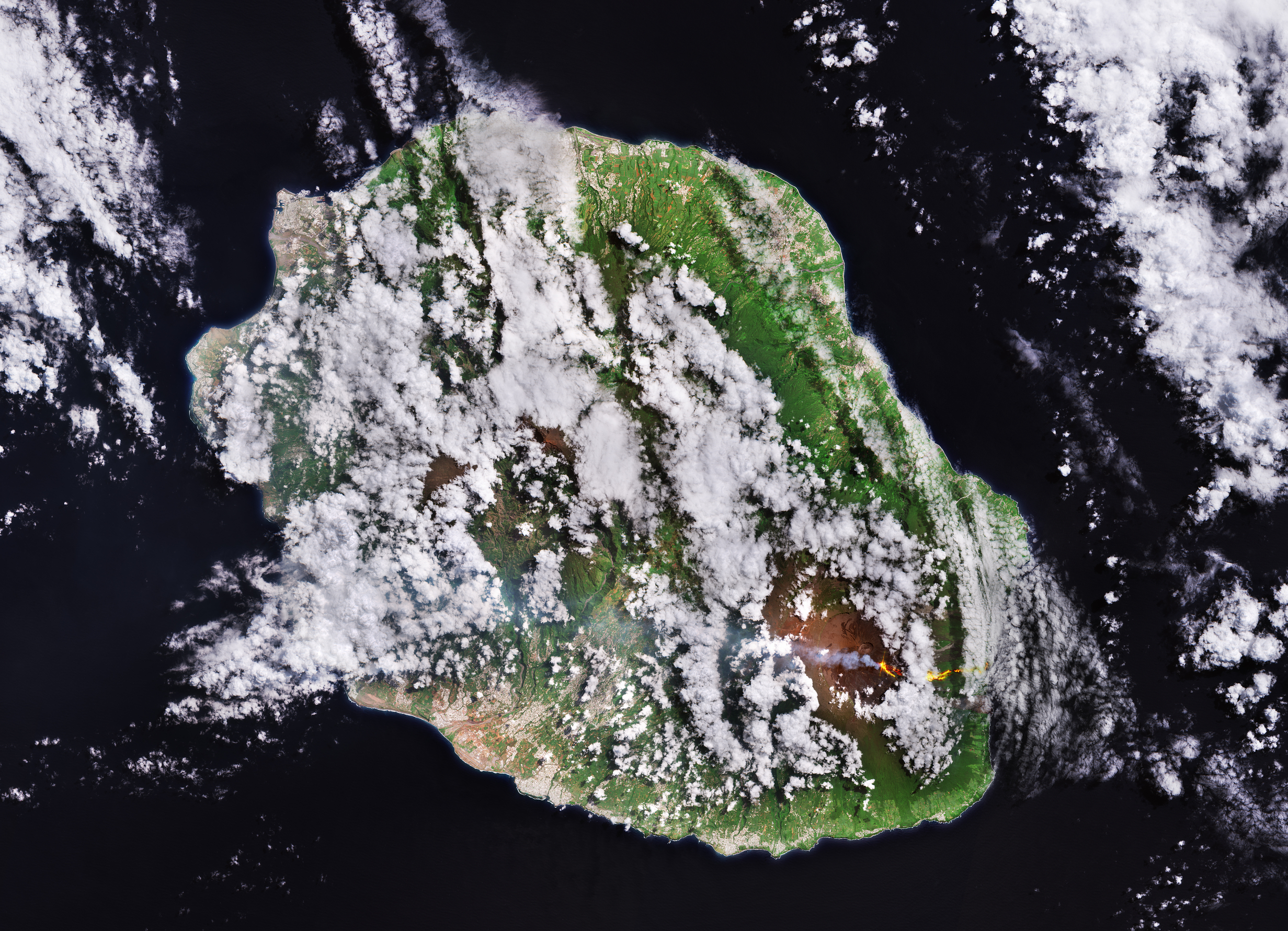
Questa immagine ottenuta da Copernicus Sentinel-2 cattura una colata lavica attiva sul vulcano Piton de la Fournaise sull'isola di Réunion.
Situata nell'Oceano Indiano occidentale, l'isola di Réunion è un dipartimento francese d'oltremare situato circa 680 km ad est del Madagascar. Le origini vulcaniche di Réunion rendono il suo paesaggio in alcuni punti particolarmente aspro, mentre in altre zone appare coperto da vegetazione rigogliosa. Terre coltivate e città, visibili come raggruppamenti di colore grigio-bianco, sono concentrati nelle pianure costiere.
La capitale e città più grande è Saint-Denis, sulla costa settentrionale, per lo più coperta da nuvole in questa immagine.
Il centro dell'isola ospita tre vasti circhi, o caldere, creati da enormi crolli. Insieme formano il vulcano a scudo dormiente - ma anche la vetta più alta dell'isola - chiamato Piton des Neiges (3069 m), che spunta in marrone da sotto le nuvole vicino al centro dell'immagine.
Sebbene Réunion ospiti più vulcani, attualmente solo uno è attivo: il vulcano scudo Piton de la Fournaise, che è uno dei più attivi sulla Terra e che domina la parte sud-orientale dell'isola. Questa immagine, ottenuta il 21 marzo 2026, mostra una colata lavica sul suo fianco occidentale, seguita ad un'eruzione iniziata a metà febbraio. Sebbene l'immagine sia stata elaborata con colori naturali, sono stati utilizzati di Sentinel-2 anche i canali infrarosso a onde corte, per evidenziare la lava infuocata che scende dal cratere, visibile qui in giallo e rosso.
Durante l'eruzione la lava ha raggiunto l'oceano, per la prima volta in quasi due decenni. In questa immagine essa è visibile mentre scorre verso la costa e si riversa nell'Oceano Indiano. Può anche essere vista una colonna di cenere e fumo che si sprigiona dal cratere e si sposta verso ovest, mentre segni di eruzioni più antiche appaiono sui fianchi del cratere come flussi di lava solidificata di colore marrone scuro.
I dati satellitari sono un ottimo mezzo per monitorare le eruzioni. Una volta iniziata un'eruzione, missioni ottiche come Copernicus Sentinel-2 possono catturare colonne di fumo, colate di lava, frane e possono essere utilizzate per aiutare a valutare i danni.
Inoltre, strumenti radar e sensori atmosferici possono fornire dati complementari per identificare fessure al suolo, la possibilità di terremoti, misurare i gas e gli aerosol rilasciati dall'eruzione e seguire la diffusione e il movimento dei pennacchi vulcanici, aiutando a valutare l'impatto ambientale ed i possibili rischi per la popolazione e per l'aviazione.
Scarica immagine Hi-Res (1,11 KB - .JPG)
Scarica immagine Hi-Res (50,23 MB - .TIF)
---
Lava flow on Réunion Island
This Copernicus Sentinel-2 image captures an active lava flow on the Piton de la Fournaise volcano on Réunion Island.
Located in the western Indian Ocean, the island of Réunion is a French overseas department about 680 km east of Madagascar. Réunion's volcanic origins make its landscape particularly rugged in places, and covered by lush vegetation in others. Cultivated land and cities, visible as grey-white clusters, are concentrated on the coastal lowlands.
The capital and largest city is Saint-Denis, on the northern coast, mostly covered by clouds in the image.
The centre of the island shelters three vast cirques, or calderas, created by huge collapses. Together they form the dormant shield volcano, and highest peak of the island, Piton des Neiges (3069 m), which peeps out in brown from beneath the clouds near the centre of the image.
Although Réunion hosts multiple volcanoes, only one is currently active: the Piton de la Fournaise shield volcano, one of the most active on Earth, which dominates the southeastern part of the island. This image, from 21 March 2026, shows a lava flow on its western flank, following an eruption that began in mid-February. Although the image has been processed in natural colour, the Sentinel-2’s shortwave infrared channels were also used to highlight the fiery lava pouring from the crater, seen here in yellow and red.
During the eruption, lava reached the ocean for the first time in nearly two decades. In this image, the lava is visible flowing towards the coast and spilling into the Indian Ocean. A plume of ash and smoke can also be seen spewing from the crater and drifting westwards, while signs of older eruptions appear on the flanks of the crater as dark brown flows of solidified lava.
Satellite data are an excellent means to monitor eruptions. Once an eruption begins, optical missions such as Copernicus Sentinel-2 can capture smoke plumes, lava flows, mudslides and can be used to help assess damage.
Furthermore, radar instruments and atmospheric sensors can provide complementary data to identify ground fissures, possible earthquakes, measure the gases and aerosols released by the eruption and follow the spread and movement of volcanic plumes, helping assess the environmental impact and possible hazards to population and aviation.
[Credits: contains modified Copernicus Sentinel data (2026), processed by ESA - Translation: Gianluca Pititto]
