
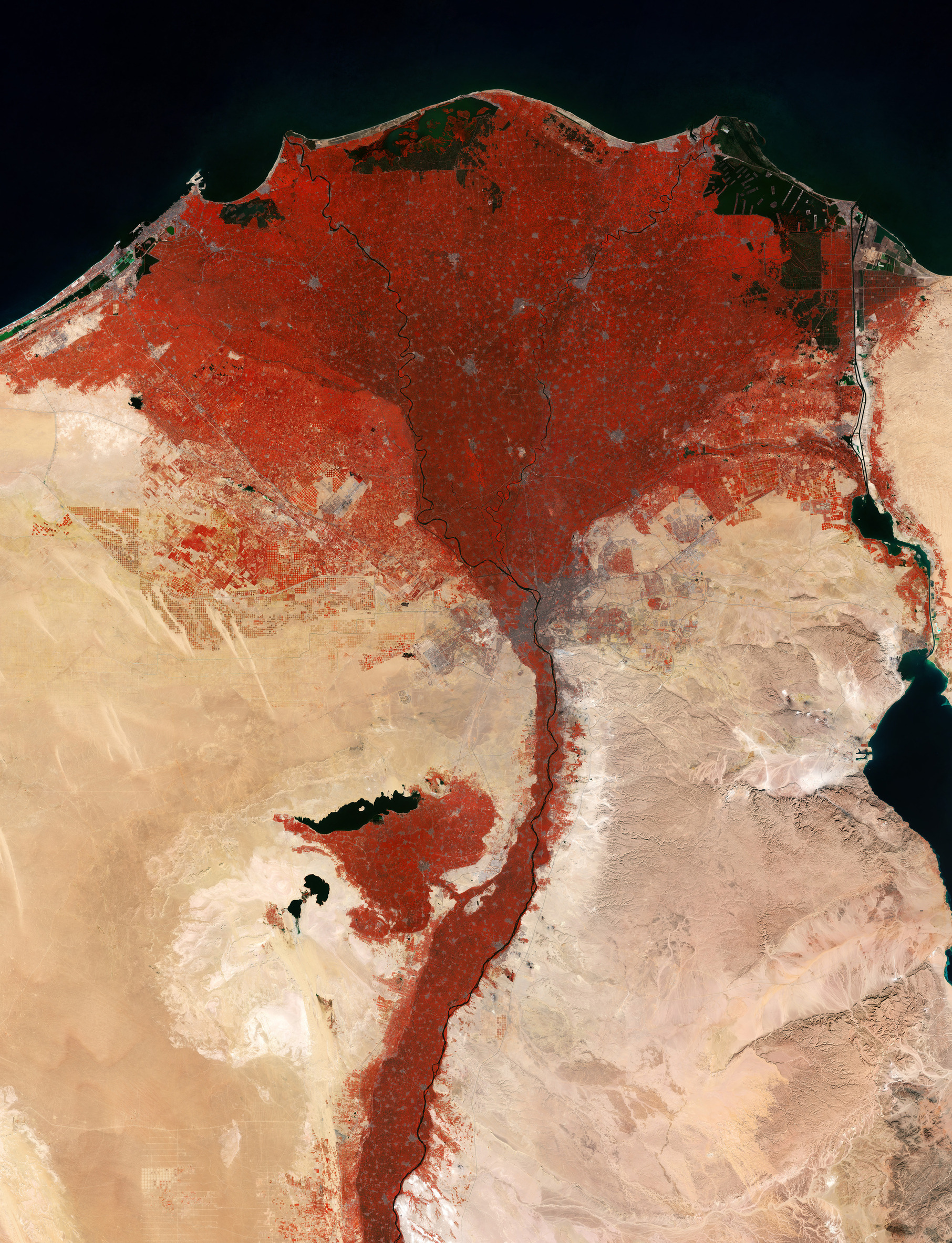
Per il giorno di San Valentino la missione Copernicus Sentinel-2 invia un messaggio d'amore dallo spazio, catturando l’oasi a forma di cuore di Faiyum appena a sud del Cairo, in Egitto.
L’immagine a falsi colori è stata elaborata utilizzando il canale del vicino-infrarosso di Sentinel-2, che evidenzia la vegetazione in rosso: per cui il delta del Nilo e l’oasi di Fayum appaiono di color rosso - un fiore rosso con un cuore naturale.
Il triangolo rosso in Egitto del fertile delta del Nilo emerge nel contrasto con il circostante deserto nord orientale africano. Questo distacco è segnato dal fiume Nilo, le cui acque, adatte allo sviluppo della vita, hanno da tempo trasformato la terra arida in un lussureggiante paesaggio agricolo.
Con meno del 3% del territorio egiziano utilizzabile in agricoltura, il delta costituisce una importante regione agricola. Si può osservare un mosaico di campi che appaiono in varie colorazioni di rosso, che riflettono le differenti coltivazioni ed i differenti stadi di crescita. Tra i prodotti chiave abbiamo cotone, riso e canna da zucchero.
Le aree urbane appaiono in grigio, con la più estesa costituita da Il Cairo, la capitale d’Egitto che sorge alla base del delta. Effettuando uno zoom possono essere riconosciute le piramidi di Giza sul plateau roccioso nei pressi del confine sud-occidentale della città.
Il confine netto tra la vegetazione rossa e il deserto color giallo-marrone rende facile tracciare il corso del fiume e rivela variazioni nella topografia. L'area coltivata si estende più a ovest del Nilo, dove un terreno più pianeggiante consente un'irrigazione più facile rispetto ai terreni più elevati a est.
A circa 100 km a sud-ovest del Cairo sorge l'oasi rossa a forma di cuore di Faiyum – una vasta depressione naturale. A differenza di altre oasi egizie, che dipendono principalmente dalle acque sotterranee, Faiyum è alimentata direttamente dalle acque del Nilo attraverso il canale Bahr Yussef. A nord di essa l'oscura distesa del Lago Qaroun – ora salino – segna i resti di quello che un tempo era un lago d'acqua dolce molto più grande.
Sul lato destro dell'immagine il Canale di Suez si estende da Port Said, sulla costa mediterranea, fino al Golfo di Suez, il braccio nord-occidentale del Mar Rosso. Essendo una delle vie d'acqua più importanti al mondo, il Canale di Suez offre un collegamento diretto tra il Mar Mediterraneo e l'Oceano Indiano.
Questa immagine è stata generata utilizzando più scansioni acquisite da Copernicus Sentinel-2 tra luglio e dicembre 2025. Selezionando nel corso del tempo pixel senza nuvole si possono creare mosaici ad alta risoluzione che risultano così chiari e particolarmente preziosi per superare le persistenti sfide della visibilità limitata causata dalla copertura nuvolosa.
Scarica immagine Hi-Res (11,61 MB - .JPG)
Scarica immagine Hi-Res (494,28 MB - .TIF)
---
Sending love from above
For Valentine’s Day, the Copernicus Sentinel-2 mission sends love from space, capturing the heart-shaped oasis of Faiyum, just south of Cairo, Egypt.
This false-colour image was processed using Sentinel-2’s near-infrared channel, which highlights vegetation in red, so that the Nile Delta and the Fayum Oasis appear in red – a red flower with a natural heart.
The red triangle of Egypt’s fertile Nile Delta stands in contrast to the surrounding desert of northeast Africa. This difference is shaped by the Nile River, whose life-giving waters have long transformed the arid land into a lush agricultural landscape.
With less than 3% of Egypt's land suitable for agriculture, the Delta is an important farming region. A patchwork of fields appears in various shades of red, reflecting different crops and growth stages. Key produce includes cotton, rice and sugar cane.
Urban areas stand out in grey, the largest being Cairo, Egypt’s capital, at the base of the Delta. Zooming in, the Pyramids of Giza can be spotted on the rocky plateau at the city’s southwestern edge.
The crisp boundary between the red vegetation and the yellow–brown desert makes it easy to trace the river’s course and reveals variations in the topography. The cultivated area extends farther west of the Nile, where flatter terrain allows for easier irrigation compared to the higher ground to the east.
Around 100 km southwest of Cairo lies the red, heart-shaped Faiyum Oasis – a vast natural depression. Unlike other Egyptian oases, which depend primarily on groundwater, Faiyum is fed directly by the Nile waters through the Bahr Yussef canal. To its north, the dark expanse of Lake Qaroun – now saline – marks the remains of what once was a much larger freshwater lake.
On the right side of the image, the Suez Canal stretches from Port Said on the Mediterranean coast to the Gulf of Suez, the northwestern arm of the Red Sea. As one of the world’s most important waterways, the Suez Canal provides a direct link between the Mediterranean Sea and the Indian Ocean.
This image was generated using multiple scans captured by Copernicus Sentinel-2 between July and December 2025. By selecting cloud-free pixels over time, such clear high-resolution mosaics can be created, which are especially valuable to overcome the persistent challenges of limited visibility owing to cloud cover.
[Credits: contains modified Copernicus Sentinel data (2025), processed by ESA - Translation: Gianluca Pititto]
