
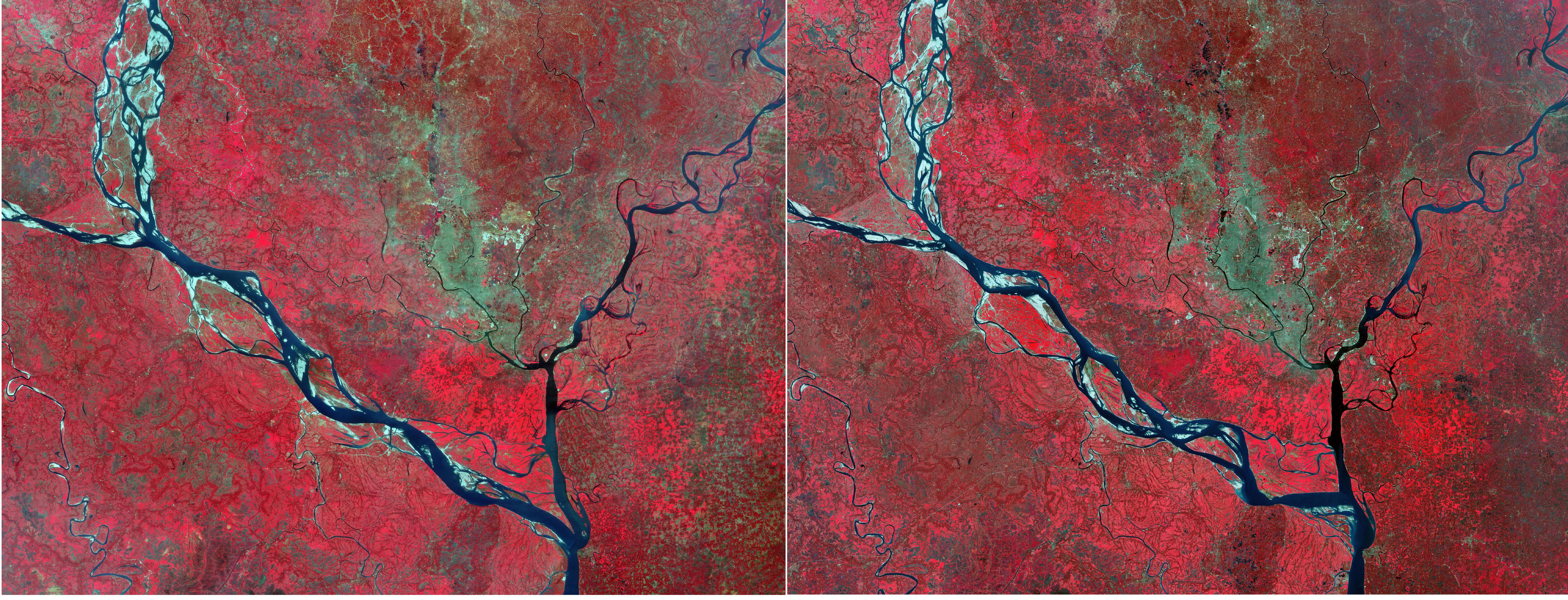
Queste due viste ottenute da Copernicus Sentinel-2 rivelano la trasformazione del paesaggio nell'area intorno a Dacca, la capitale del Bangladesh.
Questo confronto mostra Dacca ed i suoi dintorni nel febbraio 2017 (a sinistra) e febbraio 2026. Le immagini sono state elaborate in falsi colori, utilizzando il canale nel vicino infrarosso di Sentinel-2, allo scopo di mostrare la vegetazione in rosso, i corpi d'acqua in blu scuro e nero ed infine le aree con costruzioni in tonalità di grigio.
Il forte contrasto di colori rende più facile distinguere la portata dei cambiamenti avvenuti nell'area nel corso degli ultimi nove anni.
La città di Dacca, visibile in grigio vicino al centro, si trova su una pianura attraversata da una complessa rete di ruscelli e fiumi. I tre fiumi che attraversano l'area urbana sono, da ovest ad est, il Dhaleswari, il Buriganga ed il Sitalakhya, mentre la pianura circostante è delimitata dalla confluenza di fiumi più grandi: il fiume Padma ad ovest, il fiume Jamuna, un esteso sistema di canali interconnessi che converge da nord-ovest ed infine il fiume Meghna ad est.
Il Jamuna è il corso d'acqua inferiore del fiume Brahmaputra, che ha origine in Tibet prima di attraversare l'India e poi dirigersi verso sud-ovest in Bangladesh. Il Jamuna scorre verso sud e si unisce al fiume Padma, che costituisce la parte inferiore del Gange all'interno del Bangladesh. Il corso d'acqua risultante si unisce poi al fiume Meghna, che alla fine sfocia nel Golfo del Bengala.
L'area all'interno di questi possenti fiumi è una pianura alluvionale bassa fortemente influenzata dalla sedimentazione causata dal monsone e dai continui cambiamenti idrologici. Diverse aree di letti fluviali asciutti ed esposti sono visibili come chiazze di luce, specialmente lungo il sistema fluviale Jamuna-Padma.
Confrontando le due immagini si possono notare cambiamenti evidenti nella forma e nella larghezza del fiume Padma, in particolare alla confluenza con il fiume Meghna.
Le tonalità rosse che dominano entrambe le immagini rappresentano un'ampia vegetazione rigogliosa. L'immagine del 2026 evidenzia la crescita dell'espansione urbana intorno a Dacca. Le superfici edificate si sono dilatate drasticamente, inghiottendo ex aree agricole ed umide. Le zone che nel 2017 erano di un rosso acceso appaiono ora più spente, indicando esposizione del suolo, costruzioni o sigillatura superficiale.
Con una popolazione stimata di oltre 36 milioni, Dacca è la città più popolosa del Bangladesh ed è ampiamente considerata una delle regioni metropolitane dell’Asia meridionale in più rapida crescita. Come molte altre città in espansione nel mondo, si trova ad affrontare la sfida ardua della crescita urbana assieme all'aumento della densità di popolazione, fattori che entrambe pressione sul territorio urbano cittadino, ma anche sulle terre agricole periferiche, oltre che su altre risorse naturali.
Copernicus Sentinel-2 consente di monitorare accuratamente la crescita urbana, fornendo informazioni essenziali agli urbanisti ed ai decisori. La missione viene inoltre utilizzata principalmente per monitorare i cambiamenti nel modo in cui il terreno viene utilizzato e per monitorare la salute della vegetazione e dei corpi idrici interni.
Scarica immagine1 Hi-Res (5,39 MB - .JPG)
Scarica immagine1 Hi-Res (562,74 MB - .TIF)
Scarica immagine2 Hi-Res (7,28 MB - .JPG)
Scarica immagine2 Hi-Res (562,74 MB - .TIF)
---
Dhaka, Bangladesh
These two views from Copernicus Sentinel-2 reveal the landscape transformation in the area around Dhaka, the capital of Bangladesh.
This comparison shows Dhaka and its surroundings in February 2017 (left) and February 2026. The images have been processed in false colour using Sentinel-2’s near-infrared channel to show vegetation in red, water bodies in dark blue and black and built-up areas in tones of grey.
The strong contrast of colours makes it easier to distinguish the scale of changes that have occurred in the area in the past nine years.
The city of Dhaka, visible in grey near the centre, lies on a plain crossed by a complex network of streams and rivers. The three rivers crossing the urban area are, from west to east, the Dhaleswari, Buriganga and Sitalakhya rivers, while the surrounding plain is bounded by the confluence of larger rivers: the Padma River to the west, the Jamuna River, an extensive interconnected channel system converging from the northwest, and the Meghna River to the east.
The Jamuna is the lower stream of the Brahmaputra River, which originates in Tibet before flowing through India and then southwest into Bangladesh. The Jamuna flows south and joins the Padma River, which is the lower section of the Ganges within Bangladesh. The resulting stream then meets the Meghna River, which eventually flows into the Bay of Bengal.
The area within these mighty rivers is a low-lying floodplain heavily influenced by monsoon-driven sedimentation and continuous hydrological change. Several areas of dry and exposed riverbeds are visible as light patches, especially along the Jamuna-Padma river system.
Comparing the two images, noticeable changes in the shape and width of the Padma River can be noticed, in particular at the confluence with the Meghna River.
The red tones dominating both images depict extensive lush vegetation. The 2026 image highlights the growth of urban sprawl around Dhaka. Built-up surfaces have expanded dramatically, engulfing former agricultural and wetland areas. Zones that were bright red in 2017 appear now duller, indicating soil exposure, construction or surface sealing.
With an estimated population of over 36 million, Dhaka is Bangladesh’s most populous city and is widely considered as one of the fastest growing metropolitan regions in South Asia. Like many other growing cities in the world, it is facing the daunting challenge of urban sprawl along with the rise in population density, both of which put pressure on urban land in the city, but also on agricultural land in the periphery, as well as on other natural resources.
Copernicus Sentinel-2 allows urban growth to be monitored accurately, providing essential information to urban planners and decision-makers. The mission is also mostly used to track changes in the way land is being used and to monitor the health of vegetation as well as inland water bodies.
[Credits: contains modified Copernicus Sentinel data (2017/2026), processed by ESA - Translation: Gianluca Pititto]
