
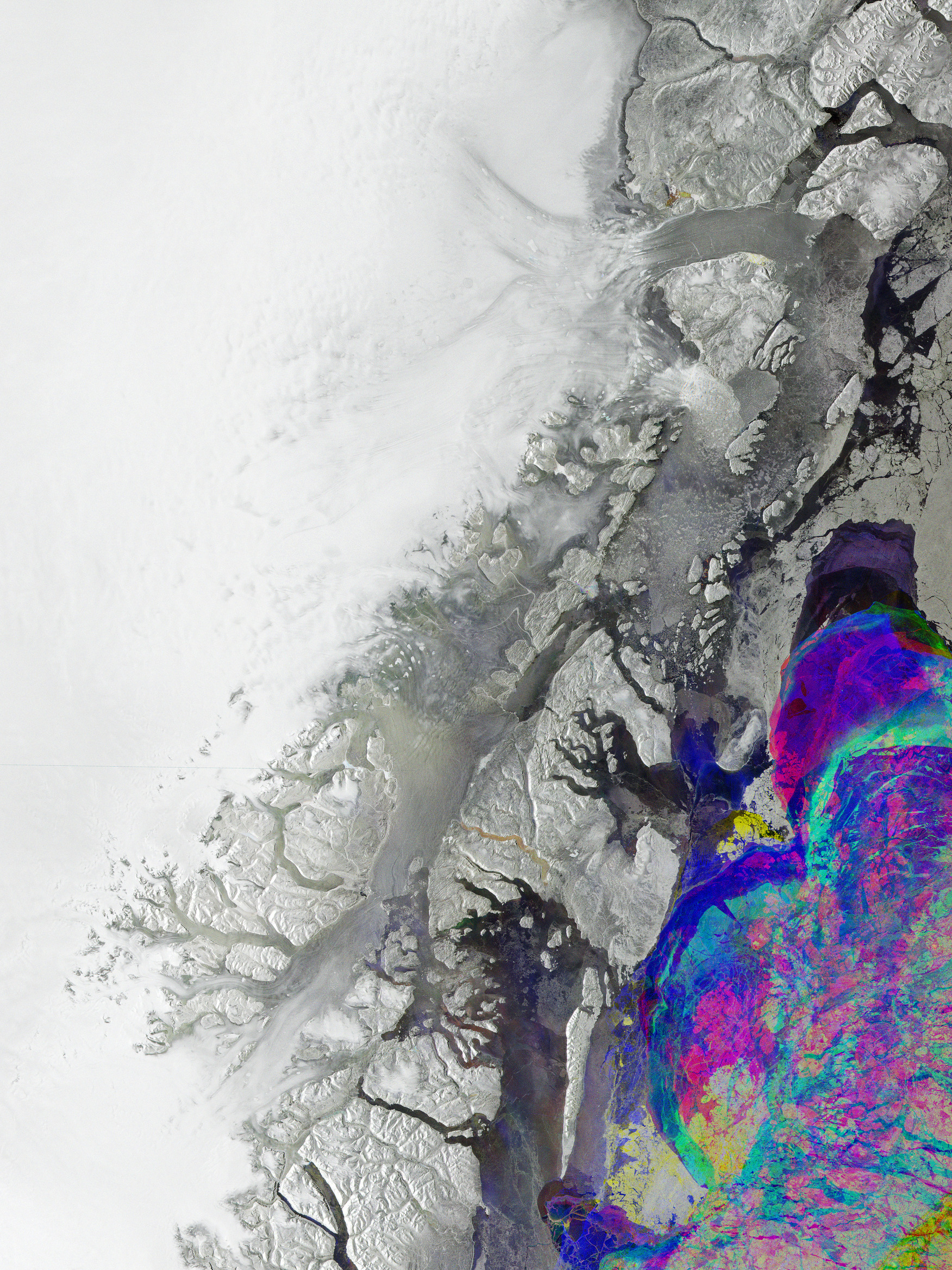
Questa immagine radar acquisita da Copernicus Sentinel-1 mostra parte della costa nord-orientale della Groenlandia, aspra e profondamente indentata.
La Groenlandia è la più grande isola al mondo e circa 80% della sua superficie è coperta da calotta glaciale, la seconda più grande massa di ghiaccio della Terra dopo la Calotta Polare Antartica.
Questa immagine combina tre acquisizioni ottenute dal radar di Sentinel-1 sopra la stessa area e nei mesi di gennaio, febbraio e marzo del 2026. Le immagini radar di regola non sono a colori, ma in questo caso è stato assegnato un colore differente a ciascuna acquisizione ed in caso di sovrapposizione i colori risultanti rappresentano variazioni che si sono verificate sulla superficie tra le tre acquisizioni.
Ghiaccio stabile può essere individuato di colore bianco a sinistra nell’immagine, mentre le ombre di colore grigio mostrano superfici caratterizzate da assenza di cambiamenti o dall'occorrenza di cambiamenti minimi. I colori sono principalmente concentrati nelle acque lungo la costa e rendono visibili cambiamenti nel tipo e nella copertura di ghiaccio marino costantemente in movimento.
Nell’immagine sono visibili i tre principali ghiacciai di sbocco: il 79N (Nioghalvfjerdsfjorden) ed il Zachariae Isstrøm a nord e lo Storstrømmen a sud. Questi ghiacciai costituiscono i principali fronti del Northeast Greenland Ice Stream (NEGIS), un lungo flusso di ghiaccio che connette le aree interne all’oceano, drenando nel Nord Atlantico approssimativamente il 12-17% della Calotta Glaciale della Groenlandia.
Il riscaldamento globale sta determinando il rapido scioglimento della calotta glaciale della Groenlandia. La perdita attuale di massa di ghiaccio sta già colpendo le regioni costiere, comprese le zone più basse, vulnerabili ad inondazioni e mareggiate. La calotta glaciale della Groenlandia contiene il 12% del ghiaccio appartenente ai ghiacciai mondiali e, se si dovesse sciogliere completamente, i mari globali aumenterebbero di livello fino a 7 m, con conseguenze catastrofiche. Inoltre, qualsiasi aumento dello scioglimento di questa calotta glaciale può causare un afflusso di acqua dolce nell'Atlantico settentrionale, indebolendo la Corrente del Golfo e potenzialmente influenzando in modo serio il clima dell'Europa settentrionale, così come quello di altri continenti.
È quindi fondamentale monitorare in modo sostenibile i suoi mutamenti di forma e la velocità con cui si scioglie. La costellazione Sentinel-1 fotografa l'intera Terra ogni sei giorni, il che è importante per monitorare i cambiamenti rapidi. Ogni satellite trasporta uno strumento radar avanzato, che cattura immagini della superficie terrestre attraverso nuvole e pioggia, indipendentemente dal fatto che sia giorno o sia notte. Questo è particolarmente utile quando si osservano queste vaste ed inaccessibili aree, soggette a lunghi periodi di maltempo ed oscurità prolungata.
Le osservazioni dallo spazio del deflusso della Groenlandia possono essere utilizzate per verificare come i modelli climatici simulano lo scioglimento delle calotte glaciali, il che permetterà previsioni migliori su quanto la Groenlandia potrà contribuire in futuro all'innalzamento globale del livello del mare.
Scarica immagine Hi-Res (23,74 KB - .JPG)
Scarica immagine Hi-Res (339,84 MB - .TIF)
---
Greenland’s changing ice
Part of the rugged and deeply indented coast of northeastern Greenland is featured in this radar image captured by Copernicus Sentinel-1.
Greenland is the world's largest island and about 80% of its surface is covered by the Greenland Ice Sheet, the second largest ice mass on Earth after the Antarctic Ice Sheet.
This image combines three acquisitions taken by Sentinel-1’s radar over the same area in January, February and March 2026. Radar images are not usually in colour, but here each acquisition has been assigned a different colour, and, when overlaid, the resulting colours represent variations that have occurred on the surface between the three scans.
Stable ice can be seen in white in the left of the image, while the shades of grey depict surfaces that have either not changed or changed very little. Colours are mainly concentrated in the water along the coast and show visible changes in type and cover of the constantly moving sea ice.
Three main outlet glaciers are visible in the image: the 79N (Nioghalvfjerdsfjorden) and the Zachariae Isstrøm to the north and the Storstrømmen to the south. These glaciers constitute the main front ends of the Northeast Greenland Ice Stream (NEGIS), a long ice stream that connects the interior to the ocean, draining approximately 12–17% of the Greenland Ice Sheet into the North Atlantic through these three glaciers.
Global warming is driving the rapid melting of the Greenland Ice Sheet. Current ice mass loss is already affecting coastal regions, including low-lying areas vulnerable to flooding and storm surges. The Greenland Ice Sheet contains 12% of the world’s glacier ice and if it melts completely, the global seas will rise by up to 7 m with catastrophic consequences.
Furthermore, any increase in melting from this ice sheet can cause an influx of freshwater into the North Atlantic, weakening the Gulf Stream and potentially seriously affecting the climate of northern Europe as well as other continents.
It is therefore vital to monitor its changing shape and the rate at which it is melting in a sustained manner. The Sentinel-1 constellation images the entire Earth every six days, which is important for monitoring rapid change. Each satellite carries an advanced radar instrument that captures images of Earth’s surface through cloud and rain and regardless of whether it is day or night. This is particularly useful when observing these vast, inaccessible areas which are prone to long periods of bad weather and extended darkness.
Observations of Greenland runoff from space can be used to verify how climate models simulate ice sheet melting, which will allow improved predictions of how much Greenland will contribute to the global rise of sea level in the future.
[Credits: contains modified Copernicus Sentinel data (2026), processed by ESA - Translation: Gianluca Pititto]
