
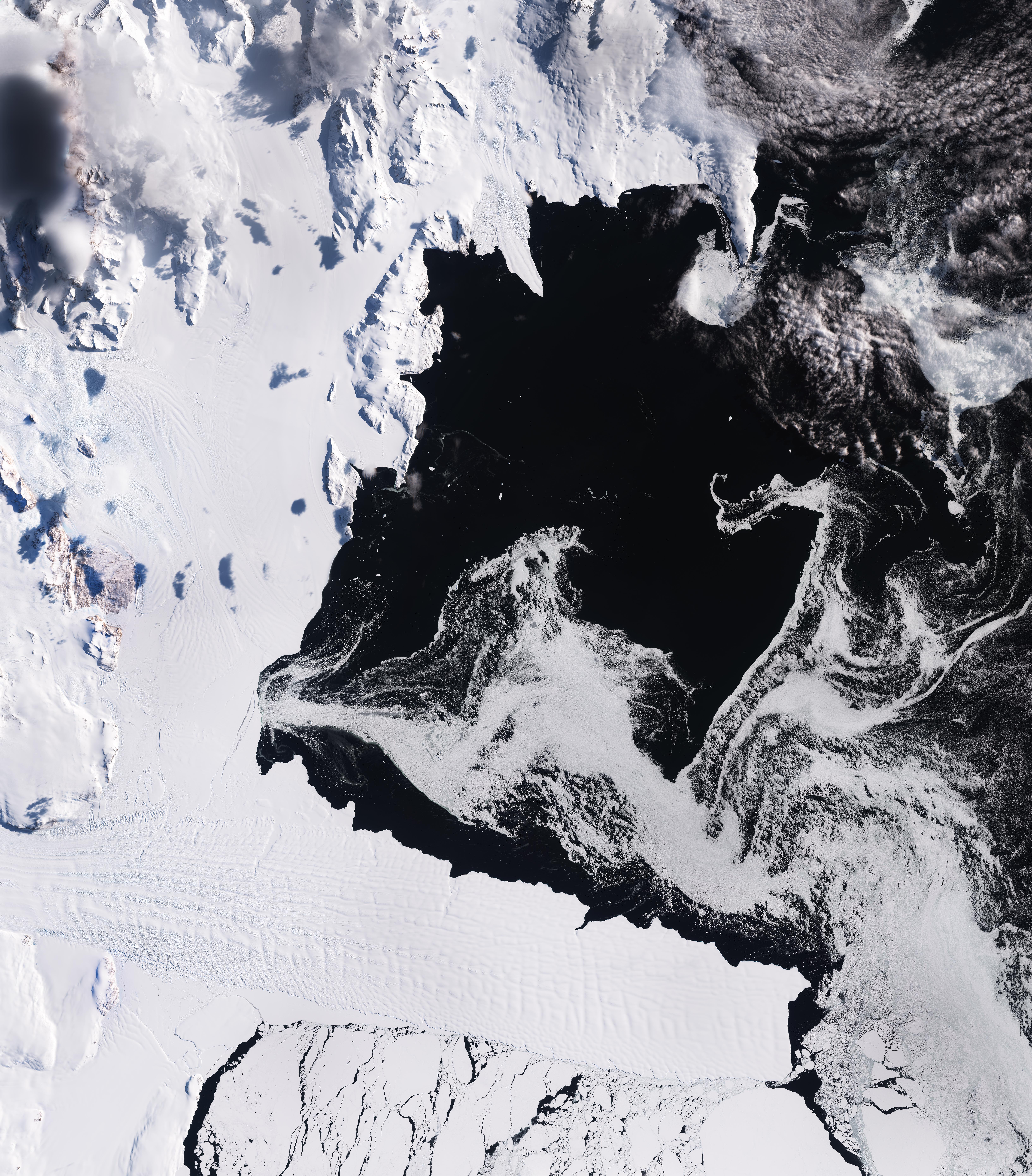
La missione Copernicus Sentinel-2 ci mostra il paesaggio ghiacciato della baia di Terra Nova nell'Antartide orientale.
La baia si trova sulla costa di Victoria Land, sul Mare di Ross – un'estensione dell'oceano meridionale – ed è delimitata dal promontorio di Cape Washington a nord e dalla Drygalski Ice Tongue a sud.
Questa immagine del 14 febbraio, che nell'emisfero sud cade alla fine dell'estate, mostra condizioni minime stagionali di ghiaccio marino, con vaste aree di acqua liquida che appaiono nere. Il ghiaccio marino bianco e grigio, in vari stadi, galleggia nell'acqua: da croste sottili ed appena formate a banchi più spessi. Questi innumerevoli pezzi di ghiaccio segnano le correnti oceaniche sottostanti, dando origine a grandi forme vorticose.
Nella parte inferiore dell'immagine si possono vedere blocchi più grandi di ghiaccio marino ed iceberg, all'estremità verso il mare di Drygalski e sotto di essa. Questo lungo e stretto strato di ghiaccio glaciale si estende per 70 km fino al mare, fungendo da estensione del ghiacciaio terrestre David.
A nord di Drygalski possiamo notare l'ampia distesa bianca della calotta glaciale di Nansen, alimentata da diversi ghiacciai di sbocco, tra cui i ghiacciai Larsen e Reeves ad ovest e il ghiacciaio Priestley a nord. Linee di flusso si possono riconoscere sulla superficie ed indicano la direzione in cui il ghiaccio si sta muovendo verso il mare.
Sul suo lato est la calotta glaciale di Nansen comprende le Northern Foothills, una linea di colline costiere separate dal Browning Pass dalla catena montuosa Deep Freeze a nord. Qui, sul promontorio meridionale lungo l’insenatura più grande, si trova la stazione stagionale italiana Zucchelli, che opera nella zona dalla metà degli anni '80. Zoomando si possono riconoscere le linee rette di una delle piste d’atterraggio che servono la stazione a pochi chilometri a sud della struttura principale.
Altre stazioni di ricerca si trovano più a nord sulla stessa insenatura: la Stazione tedesca Gondwana e la Stazione Jang Bogo della Corea del Sud. Entrambe le stazioni si trovano in prossimità della foce del ghiacciaio Campbell, la cui lingua si estende nella baia in direzione sud. Ancora a sud delle colline settentrionali si trova la piccola isola Inesprimibile, che sul suo margine meridionale ospita la stazione cinese di Qinlin.
Tratti dell’sola Inespressibile e della costa di Victoria Land sono insolitamente ricchi di fauna selvatica e sono stati designati dalla BirdLife International Aree Importanti per gli Uccelli, per colonie di pinguini di Adelia e di stercorari del polo sud.
Scarica immagine Hi-Res (6,96 MB - .JPG)
Scarica immagine Hi-Res (556,64 MB - .TIF)
---
Terra Nova Bay, Antarctica
The Copernicus Sentinel-2 mission captures the icy landscape of Terra Nova Bay in East Antarctica.
The bay is on the coast of Victoria Land on the Ross Sea – an extension of the Southern Ocean – and is delimited by the promontory of Cape Washington to the north and the Drygalski Ice Tongue to the south.
This image from 14 February, which is late summer in the southern hemisphere, shows minimum seasonal sea-ice conditions with large areas of open water, which appears black. White and grey sea ice at varying stages floats in the water: from thin, newly-formed crusts to thicker floes. These countless pieces of ice trace out the ocean currents beneath, resulting in large swirling shapes.
Larger blocks of sea ice and icebergs can be seen in the lower part of the image, at the seaward end of Drygalski and below it. This long, narrow sheet of glacial ice stretches for 70 km into the sea, as an extension of the land-based David Glacier.
North of Drygalski, we can see the white expanse of the Nansen Ice Sheet, fed by several outlet glaciers, including the Larsen and Reeves Glaciers to the west and the Priestley Glacier to the north. Flow lines are visible on the surface indicating the direction in which the ice is moving towards the sea.
On its east side, the Nansen Ice Sheet encompasses the Northern Foothills, a line of coastal hills separated by the Browning Pass from the Deep Freeze Range to the north. Here, on the southern headland along the larger inlet, lies the seasonal Italian Zucchelli Station, which has been operating in the area since the mid-80s. Zooming in, the straight lines of one of the runways serving the station can be spotted a few kilometres south of the main structure.
Other research stations are located further north on the same inlet: the German Gondwana Station and the Jang Bogo Station of South Korea. Both stations sit next to the mouth of Campbell Glacier, whose tongue extends southward into the bay. South of the Northern Foothills lies the small Inexpressible Island, which hosts the Chinese Qinling Station on its southern edge.
Stretches of Inexpressible Island and of the coast of Victoria Land are unusually rich in wildlife and have been designated Important Bird Areas by BirdLife International for colonies of Adelie penguins as well as south polar skuas.
[Credits: contains modified Copernicus Sentinel data (2026), processed by ESA - Translation: Gianluca Pititto]
