
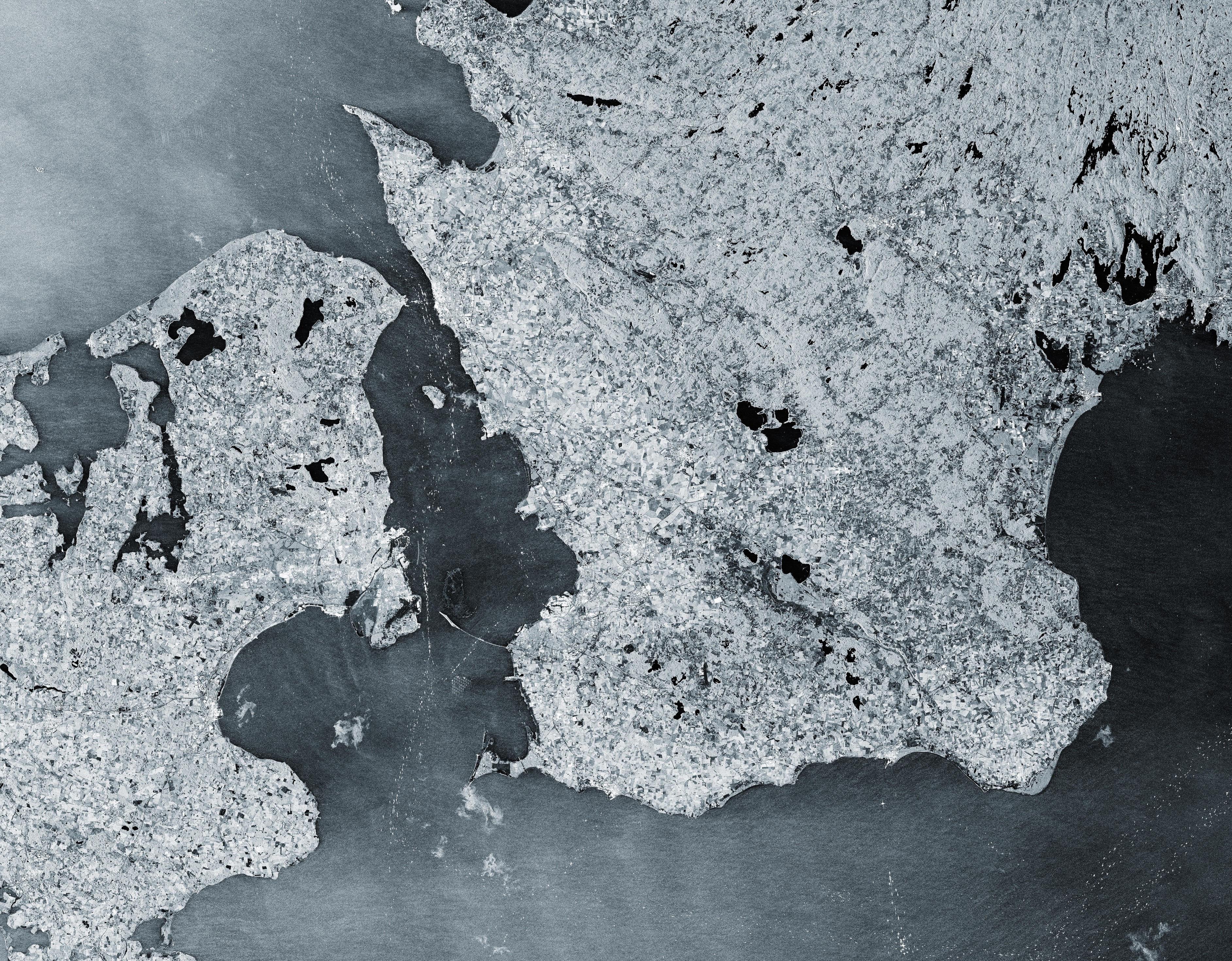
Questa immagine proviene dalla missione Copernicus Sentinel-1 e mostra il traffico marittimo che passa attraverso lo stretto di Øresund nel 2025.
Con i suoi 118 km di lunghezza lo stretto di Øresund separa la Danimarca ad ovest dalla Svezia ad est e collega il Mar Baltico con il Mare del Nord, fatto che lo rende una delle vie marittime più trafficate al mondo.
Sentinel-1 trasporta strumentazione radar in grado di fornire immagini della superficie della Terra indipendenti dalle condizioni meteo, sia diurne che notturne, caratteristiche che lo rende ideale per il monitoraggio del traffico marittimo. In questo caso, oltre 50 immagini radar della stessa area, acquisite ogni sei giorni entro il 2025, sono state accorpate in una singola immagine.
I dati radar vengono interpretati attraverso lo studio dell’intensità del segnale radar di back-scattering (di ritorno). Aree dove il segnale radar vien riflesso lontano rispetto al satellite , come avviene per i corpi d’acqua e per le superfici levigate, appaiono più scure. Viceversa, le aree per le quali il segnale viene riflesso indietro verso il satellite - come accade per le aree urbane, oggetti metallici ed infrastrutture rigide – appaiono di colore più chiaro.
In questa immagine le navi appaiono di colore chiaro, punti brillanti nelle acque scure dello stretto. Le rotte del traffico marittimo nel canale sono chiaramente individuabili, con le tratte principali evidenziate dalla concentrazione di natanti.
Appaiono molto evidenti le concentrazioni ad alta densità di punti brillanti in prossimità dei porti di Copenhagen e Malmö. Si tratta di ‘aree di sosta’ dove le imbarcazioni restano ferme per lunghi periodi, circostanza che aumenta la probabilità di essere catturate dai molteplici passaggi satellitari.
Copenhagen, la capitale della Danimarca, si trova nei pressi del centro dello stretto, sul lato orientale delle isole di Zealand ed Amager. L’aeroporto di Copenhagen è visibile come una struttura a forma di croce di colore nero sul lato orientale di Amager.
La struttura chiara ed allungata all’interno dello stretto, di fronte all’aeroporto, è l’isola artificiale di Peberholm. E’ parte del Øresund Bridge, una combinazione ponte-tunnel che attraversa lo stretto e collega Copenhagen con la città di Malmö sulla costa svedese. Peberholm funge da punto di attraversamento tra il ponte - visibile come una linea bianca e sottile al suo estremo orientale – ed il tunnel sottomarino di Drogden sul lato danese.
Il geometrico motivo di punti, visibile a sud del ponte a circa 10 km al largo della costa svedese, sono le turbine del parco eolico di Lillgrund, il più vasto della Svezia. Un altro gruppo di turbine eoliche si possono osservare al largo della costa del porto di Copenhagen: le 20 turbine del parco eolico di Middelgrunden appaiono come un filare di perle lungo 3-4 km sulle acque scure dello stretto.
Scarica immagine Hi-Res (18,56 MB - .JPG)
Scarica immagine Hi-Res (502,27 MB - .TIF)
---
Maritime highways in the Øresund Strait
This image from the Copernicus Sentinel-1 mission shows us the maritime traffic passing through the Øresund Strait in 2025.
The 118-km-long Øresund Strait (also known as the Sound) separates Denmark to the west from Sweden to the east and links the Baltic Sea to the North Sea, which makes it one of the busiest waterways in the world.
Sentinel-1 satellites carry radar instruments to provide an all-weather, day-and-night supply of imagery of Earth’s surface, making it ideal to monitor ship traffic. Here, more than 50 radar images over the same area, acquired every six days throughout 2025, have been compressed into a single image.
Radar data are interpreted by studying the intensity of the backscattered radar signal. Areas where the radar signal is reflected away from the satellite, such as water bodies and smooth surfaces, appear darker, while areas where the signal is reflected back to the satellite, such as urban areas, metal objects or hard infrastructure, appear lighter.
In this image, ships appear as bright, sparkly dots in the dark waters of the strait. The routes of marine traffic are clear to see in the channel with the main shipping lanes highlighted by the concentration of ships.
Most notable are the high-density clusters of bright points near the ports of Copenhagen and Malmö. These are ‘waiting areas’ where ships remain stationary for longer periods, increasing the probability of being captured across multiple satellite passes.
Copenhagen, Denmark’s capital, is near the centre of the strait on the eastern side of the islands of Zealand and Amager. Copenhagen Airport is visible as a cross-shaped, black structure on the eastern side of Amager.
The bright, elongated feature in the strait in front of the airport is the artificial island of Peberholm. It is part of the Øresund Bridge, a combined bridge-tunnel across the strait that connects Copenhagen with the city of Malmö on the Swedish coast. Peberholm serves as a crossover point between the bridge, visible as a thin, white line to its eastern end, and the Drogden underwater tunnel on the Danish side.
The geometric patterns of dots, visible south of the bridge about 10 km off the Swedish coast, are the turbines of the Lillgrund Wind Farm, which is Sweden's largest offshore wind farm. Another group of wind turbines can be seen off the coast of Copenhagen harbour: the 20 turbines of the Middelgrunden offshore wind farm appear as a 3.4-km-long string of pearls in the dark water of the strait.
[Credits: contains modified Copernicus Sentinel data (2025), processed by ESA - Translation: Gianluca Pititto]
