
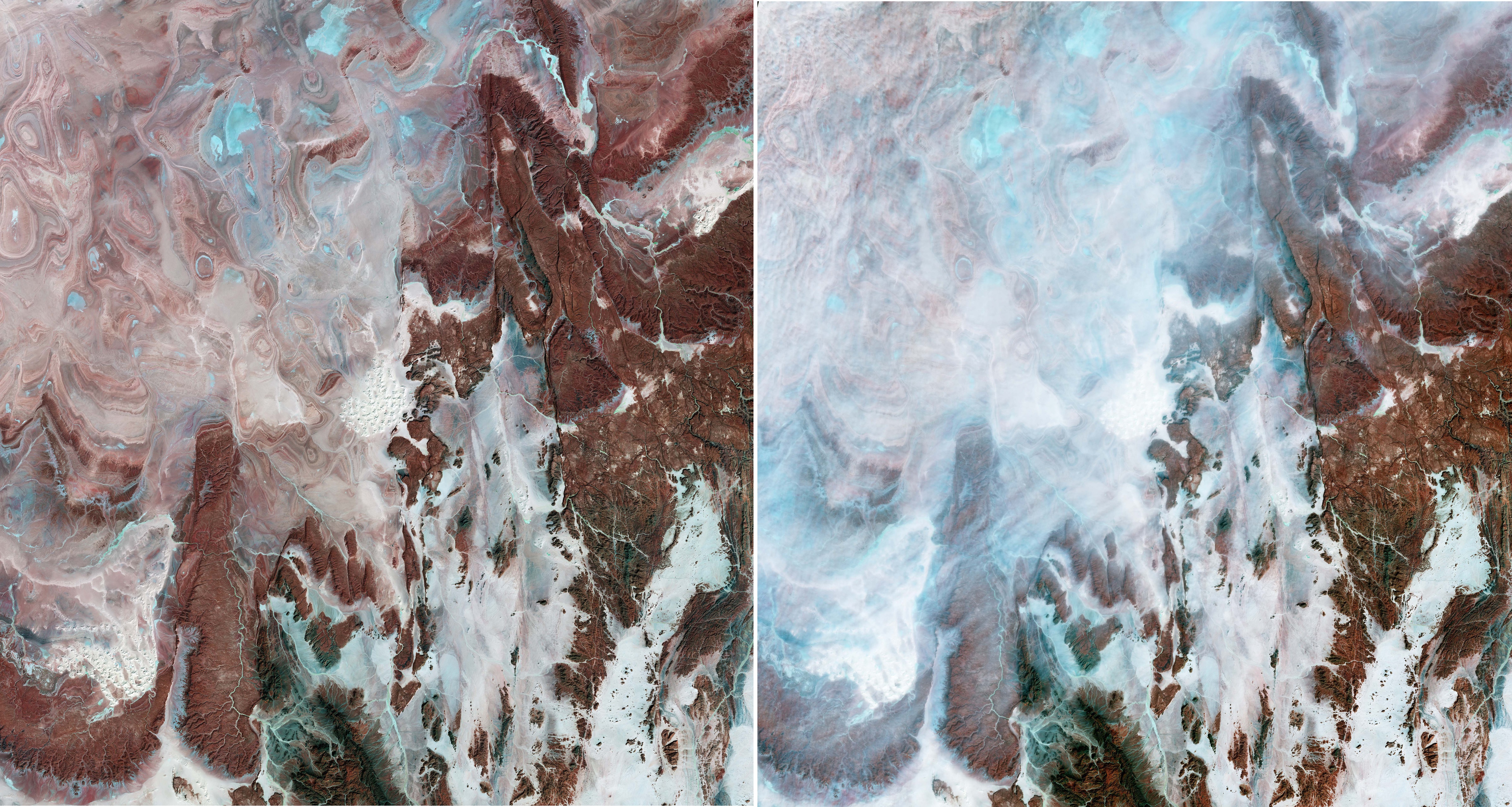
Il terreno roccioso e sabbioso del deserto del Sahara nell'Algeria centrale è mostrata in queste immagini acquisite dalla missione Copernicus Sentinel-2.
Le immagini mostrano il paesaggio straordinario all’interno del bacino Tanezrouft, una delle aree più desolate del deserto del Sahara. Conosciuta per le elevatissime temperature e per l’assenza di acqua e vegetazione, questa regione è spesso riferita come la ‘ Terra del Terrore’.
Queste due immagini sono state processate in falsi colori selezionando specifiche bande spettrali dai canali ad onde corte e del vicino infrarosso, utili per classificare e monitorare caratteristiche geologiche. In regioni estremamente aride come questa, che presentato poca vegetazione oppure una assenza completa, questa combinazione di bande migliora il contrasto tra i differenti materiali superficiali, rendendo più facile distinguere le trame geologiche ed idrologiche, comparando con le immagini in colori naturali.
Qui i colori rappresentano variazioni della composizione dei minerali della superficie, chiaramente visibili proprio grazie all’assenza di vegetazione. Le sfumature di rosso e marrone segnalano affioramenti di arenaria spoglia, ripide pareti di canyon ed altopiani rocciosi. Strati di arenaria affioranti, disposti ad anelli concentrici, danno vita a straordinari motivi, in particolare in alto a sinistra.
Le aree che mostrano colori dal ciano al bianco sono saline, bacini evaporitici, letti fluviali secchi e dune di sabbia a più livelli note come 'ergs'. La caratteristica distintiva che spicca al centro dell'immagine come un bouquet di fiori bianchi e luminosi è l'erg Mehedjibat, composto da un gruppo di piccole dune a stella che crescono verso l'alto piuttosto che attraverso.
A metà febbraio 2026 venti molto forti hanno causato lo spostamento di molta polvere sahariana in Algeria. L'immagine a destra, catturata il 14 febbraio, mostra questa enorme nuvola di polvere. La combinazione di falsi colori rivela chiaramente un distinto velo di polvere, reso in tonalità ciano, che si estende dall'angolo in alto a sinistra attraverso il centro dell'immagine. Il paesaggio roccioso e nitido che era visibile nell'immagine di sinistra del 9 febbraio risulta qui sbiadito o quasi completamente mascherato dalla tempesta.
La polvere del Sahara può essere trasportata per grandi distanze da venti forti, contribuendo ad una scarsa qualità dell'aria, pericolosa per la salute umana. I satelliti sono uno strumento prezioso per osservare vaste aree di deserto e possono monitorare ed aiutare a prevedere il movimento delle tempeste di polvere per l’attivazione di allerte precoci.
Scarica immagine1 Hi-Res (3,49 MB - .JPG)
Scarica immagine1 Hi-Res (439,64 MB - .TIF)
Scarica immagine2 Hi-Res (2,05 MB - .JPG)
Scarica immagine2 Hi-Res (439,64 MB - .TIF)
---
Algerian arid landscape
The sandy and rocky terrain of the Sahara desert in central Algeria is featured in these images captured by the Copernicus Sentinel-2 mission.
The images show the extraordinary landscape within the Tanezrouft Basin, one of the most desolate parts of the Sahara desert. Known for its soaring temperatures and its lack of water and vegetation, the region is often referred to as the ‘Land of Terror’.
These two images were processed in false colour by selecting specific spectral bands from the shortwave and near-infrared channels that can be used for classifying and monitoring geological features. In extremely arid regions such as this with little or no vegetation, this band combination enhances the contrast between different surface materials, making the geological and hydrological patterns easier to distinguish compared to natural-colour imagery.
Here, the colours represent the varying mineral composition of the surface, which is clearly visible owing to the lack of vegetation. The shades of red and brown denote bare sandstone outcrops, steep canyon walls and stone plateaus. Exposed sandstone strata of concentric rings create stunning patterns predominantly in the top left.
Areas displaying colours from cyan to white are salt flats, evaporite basins, dry riverbeds and multistorey sand dunes known as ‘ergs’. The distinctive feature that stands out as a bright white bouquet of flowers in the centre of the image is Erg Mehedjibat, which is made up of a cluster of small star dunes that grow upward rather than across.
In mid-February 2026, powerful winds triggered a lot of Saharan dust to blow across Algeria. The image on the right, captured on 14 February, shows this massive dust cloud. The false-colour combination clearly reveals a distinct dust veil, rendered in cyan hues, extending from the top-left across the centre of the image. The sharp, rocky landscape that was visible in the left image from 9 February, is here washed out or almost completely masked by the storm.
Dust from the Sahara can be carried by strong winds over vast distances, contributing to poor air quality hazardous to human health. Satellites are a valuable tool to observe large areas of desert, and can track and help predict the movement of dust storms for early-warning alerts.
[Credits: contains modified Copernicus Sentinel data (2026), processed by ESA - Translation: Gianluca Pititto]
