

At INTERGEO 2025, RIEGL introduced a trio of LiDAR systems that seem, on the surface, designed to push the envelope: the VZ-1200i terrestrial scanner, the VUX-820-G topo-bathymetric UAV sensor, and the VQX-1 Wing Pod for streamlined airborne deployments.
The company’s message was direct—higher speed, deeper reach, and easier integration. But beyond the product page gloss and press-release language lies a more nuanced picture. Are these systems a leap forward, or simply a repackaging of known capabilities? And more importantly, where do they fall short?
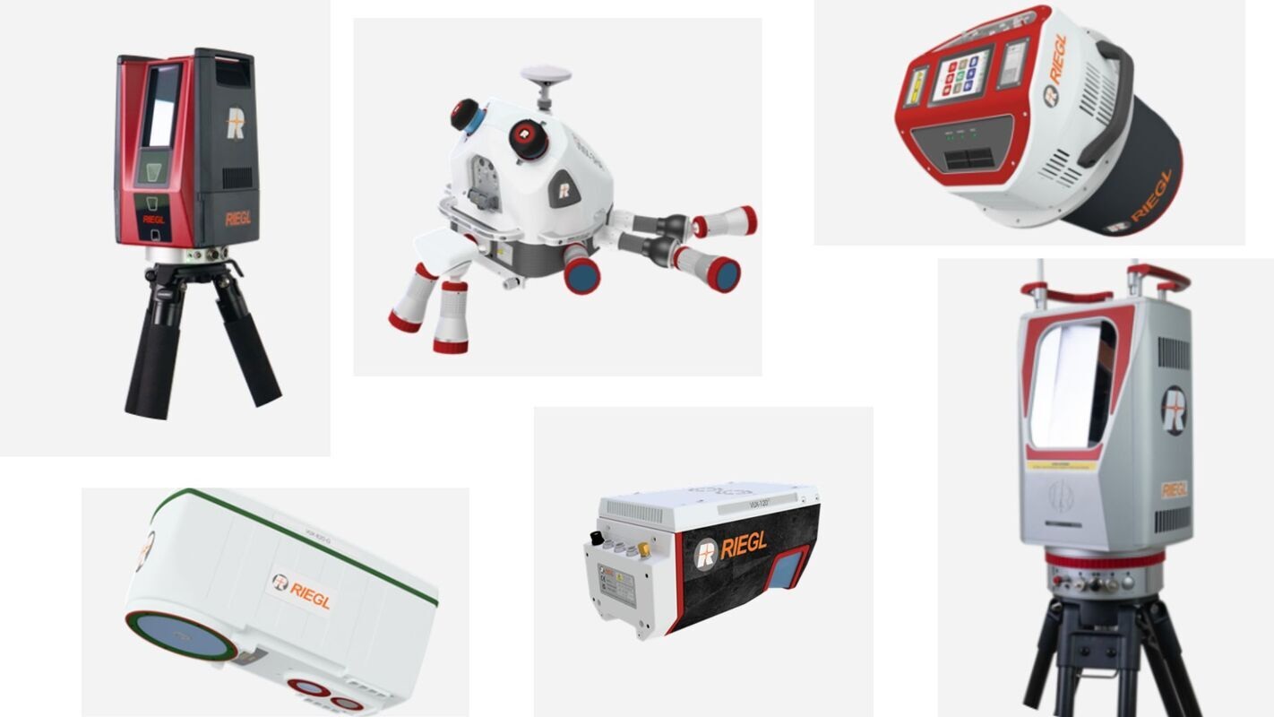
Take the VZ-1200i. Marketed as a long-range, high-speed TLS that completes a full-resolution panorama in just 25 seconds, it combines a 2.2 MHz pulse rate with standoff distances exceeding a kilometer. For large sites under tight windows—mines, unstable slopes, infrastructure corridors—this speed could indeed reduce revisit risk and operational costs. However, operating at that pulse rate introduces non-trivial concerns. Multi-time-around (MTA) logic, echo handling, and angular resolution must hold up under the strain of high-frequency operation. At long distances and oblique angles, the risk of ghosting, noise inflation, or angular creep becomes very real. Whether the scanner retains its angular precision and range fidelity in challenging conditions is an open question—one that can only be answered by field deployments, not lab metrics.
Then there's the VUX-820-G, a compact UAV payload that combines a green-wavelength topo-bathy laser, onboard GNSS/IMU, RGB camera interface, and a software license for refraction-corrected point cloud delivery. At 5.7 kg, it's clearly built with drone-borne agility in mind. The real draw is the claim of effective bathymetric penetration to roughly 2.2 times Secchi depth, which, if substantiated, would make it one of the more streamlined solutions available for shallow-water mapping from multirotors. But let’s not overstate what that means. In turbid water, over dark or irregular substrates, or under low solar angles, bathymetric performance can collapse. The 2.2x depth factor, while seductive, is not a promise—it’s a site-dependent estimate. Successful use will demand proper ground truthing, from parallel soundings to in-situ clarity tests and thorough uncertainty modeling.
The VQX-1 Wing Pod is perhaps the least flashy, yet arguably the most pragmatic of the three launches. It’s a certified payload pod for fixed-wing LiDAR missions, offering space for multiple cameras, GNSS/IMU systems, and modular RIEGL scanners. By simplifying the traditionally cumbersome process of integrating sensors into aircraft—especially across different airframes—it reduces deployment time and enhances repeatability. For aerial survey firms juggling multiple missions, this can translate into real-world efficiency. But the advantages depend entirely on calibration rigor. Without high-precision boresight alignment, tight timebase synchronization, and well-managed lever arms, even the best hardware will produce misaligned or distorted data.
What ties these systems together, apart from branding, is their shared reliance on RIEGL’s waveform processing, real-time registration features, and software continuity. The VZ-1200i, for instance, benefits from the same “kinematic” tools as previous i-series TLS units. Similarly, the VUX-820-G leverages established bathymetric pipelines with added automation. This continuity lowers the barrier for teams already embedded in the RIEGL ecosystem. But that same integration can mask complexity: fast scans, bathymetric corrections, and multi-sensor alignments all demand deep familiarity with calibration procedures, uncertainty estimation, and QA/QC workflows. There is no “turnkey” without training.
And here lies the real crux: as of October 2025, no peer-reviewed field studies exist on any of these instruments. Not a single independent benchmark, no published scan-to-truth comparisons, and no real-world validation of water-column penetration or long-range range noise. This isn’t a surprise—INTERGEO was barely a week ago—but it does mean early adopters will be flying blind unless they conduct their own rigorous validation. For critical applications—hydraulic modeling, structural monitoring, coastal bathymetry—the absence of documented performance undercuts confidence.
To be fair, RIEGL's legacy in the scientific literature is solid. Previous VZ, VUX, and VQ series systems have been thoroughly documented in peer-reviewed geomatics, photogrammetry, and remote sensing journals. But transferring that credibility to new hardware isn’t automatic. Higher speeds, tighter integrations, and expanded capabilities introduce new failure modes. Until the new instruments are tested under real-world constraints—variable weather, complex targets, field logistics—their marketing value cannot be fully translated into engineering trust.
From a practical perspective, the potential is clear. The VZ-1200i could dramatically shorten TLS campaign durations. The VUX-820-G promises to bring reliable topo-bathy to small UAVs with less configuration hassle. The VQX-1 could become a standard fixture for aerial LiDAR firms wanting predictable, aircraft-agnostic setups. For teams that already rely on RIEGL’s software and data handling chain, these systems offer a smoother upgrade path. But none of these tools is “plug and play” in the way some headlines might suggest. Each demands precise calibration, disciplined data management, and—most critically—on-site verification.
If there's one clear takeaway, it’s this: innovation in LiDAR, no matter how slick the brochure, must always be grounded in reproducible, peer-reviewed performance. RIEGL’s new systems are promising, and in many ways necessary to meet the growing demand for speed, integration, and aquatic versatility in remote sensing. But until the first round of controlled studies is published, the prudent move for practitioners is to treat these instruments as technically exciting but operationally unproven.
For serious users, the recommendation is clear: run your own tightly controlled pilot, with independent ground truthing, transparent QA metrics, and complete access to raw data. Only then can you be sure that every pulse counts.
Source: ( Riegl )
