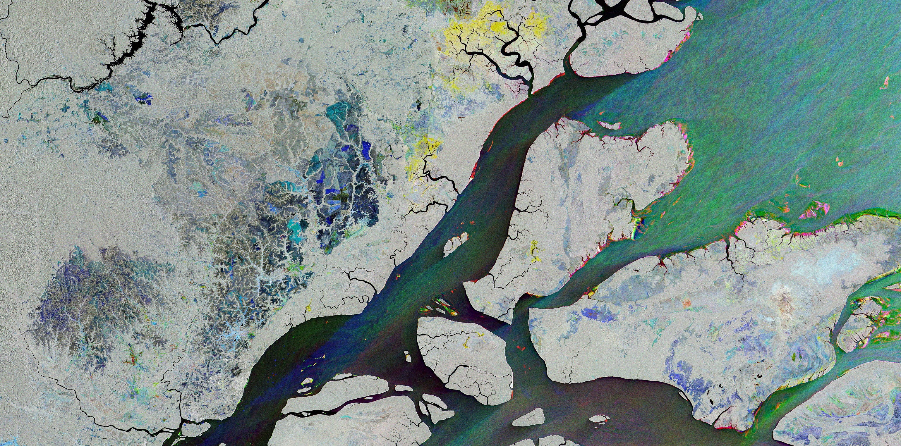
Questa immagine radar ottenuta da Copernicus Sentinel-1 mostra la foce a delta del Rio delle Amazzoni e la città di Macapá, che sorge sull'equatore ed è circondata dalla foresta pluviale amazzonica, da mangrovie e da reti fluviali.
L'immagine è un composito di acquisizioni radar ottenute in tre date nella seconda metà del 2026. Questa tecnica evidenzia dove la superficie terrestre ha subito modifiche tra una acquisizione e l'altra. Le aree che appaiono in grigio, bianco o nero hanno subito poco o nessun cambiamento. Le aree colorate sono quelle in cui sono state osservate variazioni, che potrebbero essere dovute a fattori come la crescita della vegetazione, le condizioni del mare, cedimenti del terreno o cambiamenti delle rive dei fiumi.
Le aree mostrate in blu indicano cambiamenti rilevati il 15 agosto. La maggior parte delle tonalità blu si osserva nell'entroterra, il che può suggerire una crescita della vegetazione o delle colture. Le aree verdi indicano dove sono stati osservati cambiamenti il 20 settembre, mentre il rosso segnala dove il 26 ottobre il paesaggio appariva diversamente.
La città di Macapá, che conta circa mezzo milione di abitanti, è visibile nell’immagine in basso a sinistra, sulla riva nord del Rio delle Amazzoni. È mostrata in grigio poiché la città non cambia sostanzialmente in questo arco temporale. Tuttavia, appare in blu una caratteristica del paesaggio simile a una rete a nord della città, mostrando che nel mese di agosto è stato rilevato un cambiamento probabilmente dovuto a crescita di foresta o vegetazione.
Si possono osservare variazioni lungo le rive del fiume, con evidenti aree rosse lungo la costa a nord di Macapá e lungo la costa delle isole che si trovano nel delta. Queste variazioni suggeriscono cambiamenti rilevati in ottobre nella formazione della riva del fiume, tuttavia non presenti in agosto o settembre. Anche le barche – che appaiono come minuscoli blocchi colorati sul fiume – sono visibili in blu, verde o rosso.
Le aree densamente boscose a sinistra dell'immagine sono mostrate in grigio, poichè il radar di Sentinel-1 riflette la sommità della chioma degli alberi, che è rimasta relativamente invariata in questo periodo. A nord di Macapá sono visibili reti grigie, corrispondenti ad aree boschive, molto probabilmente valli che seguono reti fluviali. Le aree colorate tra queste reti mostrano appezzamenti geometrici di campi. I cambiamenti su questo terreno potrebbero essere dovuti a cicli naturali di crescita o, nel caso delle terre agricole, alla crescita ed alla raccolta delle colture.
Scarica immagine Hi-Res (191,3 MB - .TIF)
Scarica immagine Low-Res (34,1 MB - .JPG)
---
Macapá in the Amazon Delta
This radar image from Copernicus Sentinel-1 shows the mouth of the Amazon Delta and the city of Macapá, which sits on the equator and is surrounded by Amazon rainforest, mangroves and river networks.
The image is a composite of radar acquisitions taken on three dates in the second half of 2026. This technique highlights where Earth’s surface has changed between acquisitions. Areas that appear in grey, white or black have seen little or no change. Coloured areas are where change was observed, which could be due to factors such as vegetation growth, sea conditions, land subsidence or changes to river banks.
Areas shown in blue denote change captured on 15 August. Most blue tones are seen inland, which may suggest vegetation or crop growth. Green areas are where change was observed on 20 September and red is where the landscape appeared differently on 26 October.
The city of Macapá, home to about half a million people, is visible on the lower left of the image, on the north bank of the Amazon river. It is shown in grey as the city itself does not change substantially over this timescale. However, a network-like feature of the landscape appears in blue to the north of the city, showing that a change – possibly forest or vegetation growth – was detected in August.
Changes can be seen along the banks of the Amazon, with notable red areas along the shore north of Macapá and around the coast of islands in the delta. These suggest changes to the formation of the river bank, detected in October, but not present during August or September. Boats – appearing as tiny coloured blocks on the river – are also visible in blue, green or red.
Densely forested areas on the left of the image are shown in grey, as Sentinel-1’s radar reflects off the top of the tree canopy, which remained relatively unchanged during this timeframe. To the north of Macapá, grey networks are visible – these are forested areas, most likely valleys that follow river networks. The coloured areas in between these networks include geometric patchworks of fields. Changes on this land could be due to natural growth cycles or, in the case of agricultural land, crop growth and harvesting.
[Credits: contains modified Copernicus Sentinel data (2026), processed by ESA - Translation: Gianluca Pititto]