

At INTERGEO 2025, Topcon Positioning Systems made it unmistakably clear: their geomatics division is no longer content playing a supporting role behind machine control or construction automation. With the unveiling of a broadened scanning hardware suite, deeper software integrations, and an explicit strategy aimed at enabling seamless “mass-data workflows,” Topcon has stepped into the spotlight with confident momentum—and considerable risk.
The central promise is bold. Rather than launching standalone devices that push the usual metrics of range, point density, or scanning speed, Topcon is repositioning itself as a full-stack ecosystem vendor. The emphasis now is on reducing friction—between sensors, between field and office, and between capture and decision. That’s a strong proposition, but also a demanding one. Achieving this level of interoperability and real-time processing comes with serious engineering and usability challenges that cannot be brushed aside.
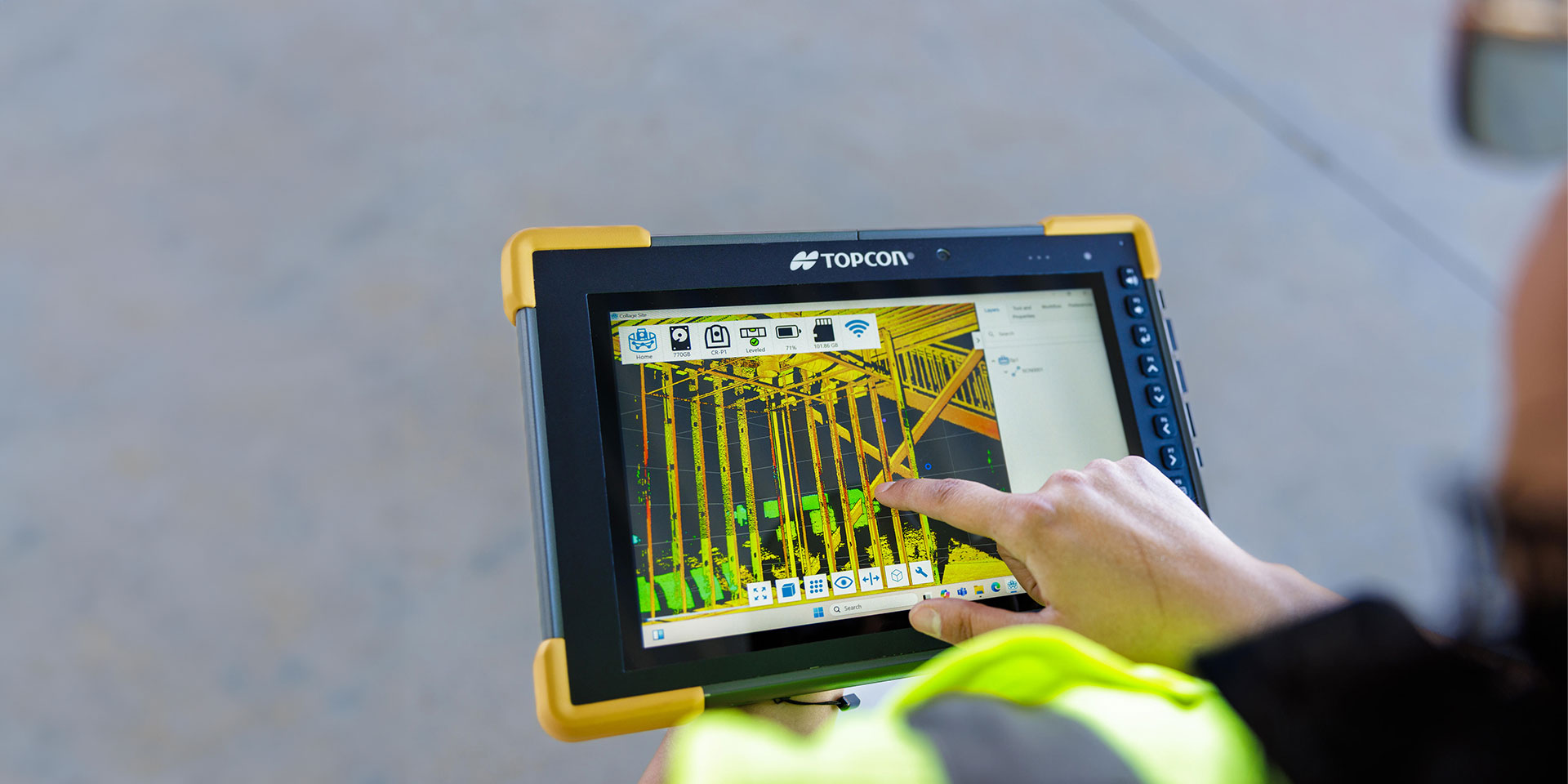
At the heart of the hardware expansion is the new family of scanning tools. Each is tailored to a different operational need, ranging from handheld scanning with the CR‑H1—which combines an iPhone’s built-in LiDAR with Topcon’s GNSS receiver for instant georeferenced capture—to more robust terrestrial units like the CR‑P1, which boasts an impressive point throughput of up to two million points per second. The CR‑M1 backpack scanner extends capability into indoor and subterranean environments, while the CR‑S2 attempts an ambitious fusion of SLAM navigation with RTK correction—a conceptually powerful combination that could offer significant benefits in feature-poor or GNSS-deprived conditions.
However, technical elegance on paper often masks operational complexity in the field. While the CR‑P1’s on-site registration and processing features—powered via Topcon’s Collage Site software—promise faster data-to-deliverable timelines, that same promise hinges on the robustness of the real-time registration engine. Algorithms such as ICP and loop closure must operate with minimal drift, especially in dynamic or visually repetitive environments. And although the scanner's claimed accuracy and noise levels seem competitive, its IP54 rating raises questions about deployment in genuinely harsh outdoor scenarios. Dust, heavy rain, and extended field shifts may test its physical resilience and power management beyond advertised specs.
Battery life is another concern. Four hours of typical runtime under load-intensive scanning and wireless data transfer is respectable, but may be insufficient for full-day field operations without well-orchestrated battery swaps or external power—especially in large-scale projects or remote sites. For some, this may feel like an acceptable compromise; for others, it may be a limitation too costly to overlook.
Meanwhile, Topcon’s decision to integrate high-end scanning capabilities from FARO within its own workflow ecosystem marks a strategic alignment worth watching. The CR‑P1 is the first fruit of that collaboration, and it represents a shift from Topcon’s past practice of prioritizing native vertical integration. This outsourcing of scanning hardware, paired with proprietary data handling, signals an openness to cross-vendor partnerships—but also increases the importance of software stability and user experience. If Collage Site or Cloud falters in fusing these diverse data streams, the entire proposition risks unraveling.
The software strategy, particularly the enhanced Collage platform and Field v10 suite, aims to weave together the disparate worlds of GNSS, robotic total stations, SLAM sensors, and scan data into a unified operational framework. In principle, this reduces the fragmentation that plagues many survey workflows. Surveyors no longer need to manually align coordinate systems, reconcile timestamps, or suffer through endless reformatting and exports. Everything—from acquisition to delivery—is intended to happen within a common interface.
But here again, theory and practice rarely align neatly. Effective real-time fusion of SLAM and RTK, for instance, is no trivial feat. It requires precise timestamp synchronization, robust sensor calibration, and a fusion model that can gracefully handle divergent update rates, measurement noise, and spatial drift. Incomplete loop closures, misaligned scans, or timestamp inconsistencies can introduce subtle—but dangerous—artifacts into the final dataset. Without thorough transparency on how Topcon manages these technical nuances, professionals should remain cautiously optimistic rather than uncritically enthusiastic.
On the usability front, Topcon deserves credit. The LN‑1000i layout instrument, paired with Digital Layout 2.0, incorporates a range of small yet meaningful improvements: reflectorless measurement, a visible green laser for better daylight visibility, and an integrated live camera view. These refinements may seem marginal, but in the often-chaotic environment of construction layout, clarity, speed, and confidence matter as much as raw measurement fidelity. Coupled with tilt-compensated prism workflows and hybrid GNSS/total station switching, these enhancements reflect a welcome responsiveness to real-world site conditions.
Still, none of these advances will mean much without rigorous independent validation. As of October 2025, there is no peer-reviewed literature evaluating the CR‑P1 or its software companions in the field. No published benchmarks, no comparative case studies, no long-term monitoring results. This is perhaps understandable—new tools need time to reach research labs—but it’s a critical gap nonetheless. Until surveyors, academics, or third-party testers produce robust data on real-world noise, registration drift, SLAM fusion accuracy, and system uptime, all performance claims must be treated as provisional.
In short, Topcon is reaching for something bigger than a new scanner or layout tool. The vision is holistic: a networked, modular, interoperable ecosystem that handles complexity behind the scenes so the field team doesn’t have to. It’s an attractive ideal, and if they can execute it reliably at scale, it could meaningfully alter how geomatics professionals work—particularly in time-sensitive, high-volume contexts.
But this ambition comes with pressure. Integration increases dependency. Users who commit fully to the Topcon platform may find themselves locked into proprietary workflows, constrained by limited cross-compatibility and the pace of Topcon’s own update cycles. Conversely, if the integration works as advertised and the tools deliver robust, real-time performance, the value proposition is substantial: reduced rework, faster feedback, tighter coordination, and ultimately, higher quality outcomes.
Whether Topcon’s INTERGEO 2025 showcase marks a turning point or an overreach will depend not on their roadmap, but on the results delivered in mud, rain, and real-world complexity. Until then, these tools remain full of promise—and in need of proof.
Source: ( Topcon Positioning )
