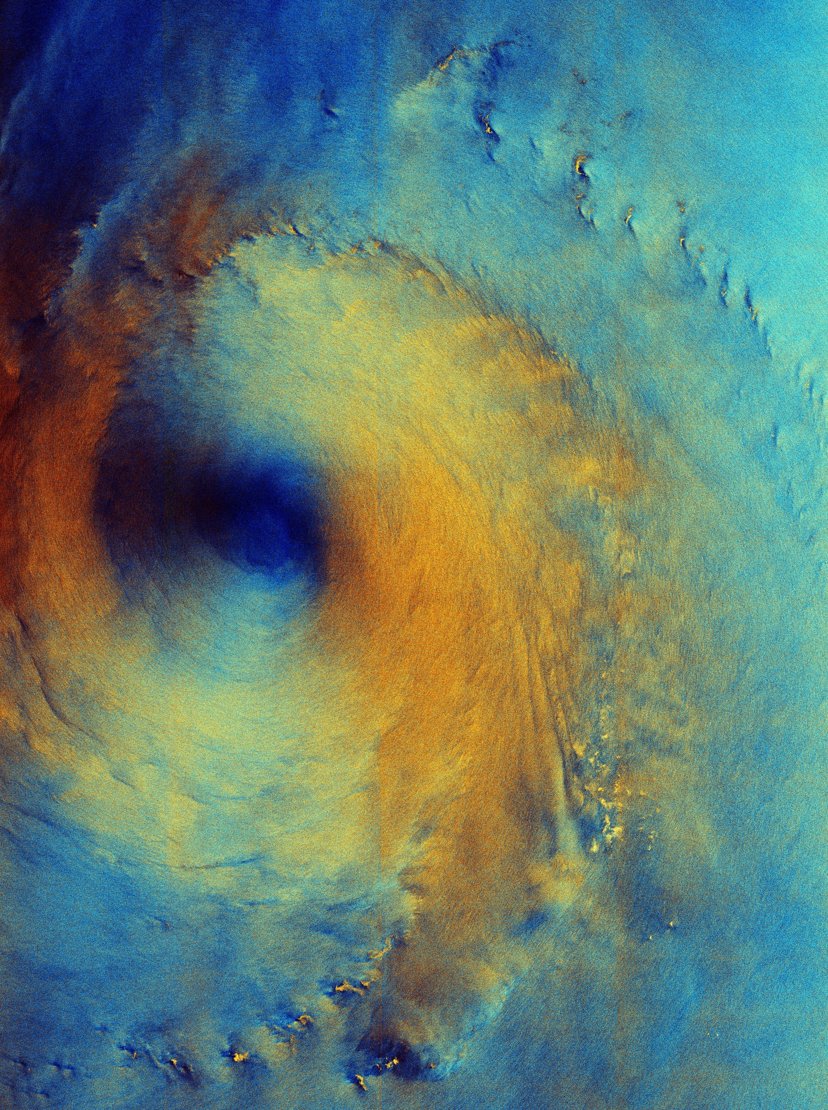
Siamo abituati a vedere le immagini satellitari delle tempeste tropicali da sopra le nuvole, con le caratteristiche spirali bianche che roteano intorno all'occhio della tempesta. Questa immagine polarizzata a falsi colori ripresa da Copernicus Sentinel-1 ci mostra la superficie del mare sotto le nuvole, come osservata dalla strumentazione radar del satellite. Le condizioni del mare riflettono i forti venti, mentre il tifone Surigae scorre sopra di esso.
L'immagine, acquisita il 28 settembre 2026, mostra il tifone Surigae mentre si muoveva verso nord-est in un'area del Mare delle Filippine, a circa 200 km a sud dell'isola di Shikoku, in Giappone. Al 1° ottobre la tempesta, classificata anche come ‘Tifone n. 26’, si trovava a quasi 1000 km di distanza, a circa 200 km a sud di Tokyo. Attualmente è uno dei diversi tifoni presenti nel Pacifico.
In questa immagine i mari relativamente calmi nell'occhio della tempesta sono chiaramente visibili in blu scuro. L'effetto colorato è creato utilizzando due polarizzazioni radar, ognuna assegnata ad un colore diverso. L'anello arancione-giallo nell'immagine indica il punto in cui lo strumento radar ha rilevato condizioni oceaniche agitate e venti forti.
Le aree blu più chiare mostrano dove il radar ha rilevato un tipo diverso di segnale e verosimilmente indicano condizioni oceaniche e di vento che differiscono dalle aree gialle e arancioni brillanti. Alcune delle possibili cause sono le più basse velocità del vento, minore movimento della superficie del mare o aree di pioggia.
Nella parte inferiore dell'immagine si vedono alcune macchie giallo brillante. Sebbene appaiano simili a piccole isole, non ci sono masse terrestri in quella regione ed è più probabile che si tratti di aree di vento e pioggia concentrati.
Quando questa immagine radar è stata acquisita il tifone Surigae aveva venti forti con raffiche massime fino a 240 km/h, con condizioni oceaniche pericolose, tra cui forti mulinelli ed onde fino a 7 m di altezza. Da allora si è notevolmente indebolita ed è attualmente classificata come depressione tropicale, con velocità massime del vento di 55 km/h.
Scarica immagine Hi-Res (8,48 MB - .JPG)
Scarica immagine Hi-Res (200,58 MB - .TIF)
---
Typhoon Surigae
We are used to seeing satellite images of tropical storms from above the clouds, featuring the characteristic white swirls around the eye of the storm. This false-colour, polarised image from Copernicus Sentinel-1 shows us the surface of the sea beneath the clouds, as seen by the satellite’s radar instrument. The sea conditions reflect the strong winds as Typhoon Surigae passes over.
The image, captured on 28 September 2026, shows Typhoon Surigae as it was moving north-eastwards in an area of the Philippine Sea about 200 km south of the island of Shikoku, Japan. By 1 October, the storm, also known as Typhoon no. 26, was almost 1000 km away, roughly 200 km south of Tokyo. It is one of several typhoons in the Pacific Ocean at the moment.
The relatively calm seas at the eye of the storm are clearly visible in dark blue in this image. The colorful effect is created using two radar polarisations, each assigned to a different colour. The orange-yellow ring in the image is where the radar instrument has detected rough ocean conditions and strong winds.
The lighter blue areas of the image show where the radar has detected a different kind of signal and it most likely denotes ocean and wind conditions that differ to the bright yellow and orange areas. Some of the possible causes are lower wind speeds, less sea surface movement or areas of rain.
Some bright yellow flecks are seen in the lower part of the image. While these look like small islands, there are no land masses in that region – they are most likely to be areas of concentrated wind and rain.
When this radar image was acquired, Typhoon Surigae had strong winds with maximum gusts of up to 240 km per hour, with dangerous ocean conditions including strong swells and waves reaching up to 7 m. Since then, it has weakened considerably and is currently classed as a tropical depression, with maximum wind speeds of 55 km per hour.
[Credits: contains modified Copernicus Sentinel data (2026), processed by ESA - Translation: Gianluca Pititto]