An interview with NV5's Principal AI Architect Chancee Vincent highlights a critical transition in geospatial intelligence: moving beyond isolated AI models towards integrated, human-supervised workflows connecting LiDAR, remote sensing, GIS and enterprise systems.
Artificial intelligence is increasingly embedded in geospatial technologies, from automated feature extraction to satellite image interpretation and LiDAR point cloud classification. Yet, despite significant advances in machine learning, many organizations still struggle to transform experimental applications into reliable operational processes. The challenge is no longer simply developing more sophisticated algorithms. It is connecting geospatial data, analytical tools and human expertise within coordinated workflows capable of producing actionable intelligence. This distinction is at the centre of a recent interview published by LIDAR Magazine with Chancee Vincent, Principal AI Architect at NV5, who discusses how agentic AI could change the way geospatial organizations manage data, automate complex processes and support operational decision-making.
Beyond AI Models: The Importance of Workflow Intelligence
Many geospatial organizations have already tested artificial intelligence through pilot projects, proofs of concept and individual automated tasks. However, integrating these capabilities into everyday operations remains considerably more challenging. Geospatial analysis involves multiple interconnected activities: identifying suitable datasets, validating their quality, selecting processing tools, interpreting results and transferring information into operational systems.
Traditional AI applications generally address individual tasks, such as object detection or image classification. Operational GeoAI requires a broader approach, in which different models, software platforms and data sources operate within a coordinated process. Vincent describes this transition through the concept of workflow intelligence: the ability to connect AI capabilities with enterprise systems, established analytical procedures and the expertise of geospatial professionals.
Agentic AI and the Integration of LiDAR, Imagery and GIS
Agentic AI introduces systems capable of interpreting user objectives, selecting appropriate tools and coordinating sequences of analytical operations. In a LiDAR-based monitoring application, for example, an AI agent could help identify relevant point clouds, verify geographical coverage and acquisition dates, initiate processing, compare results with previous surveys and prepare information for expert review.
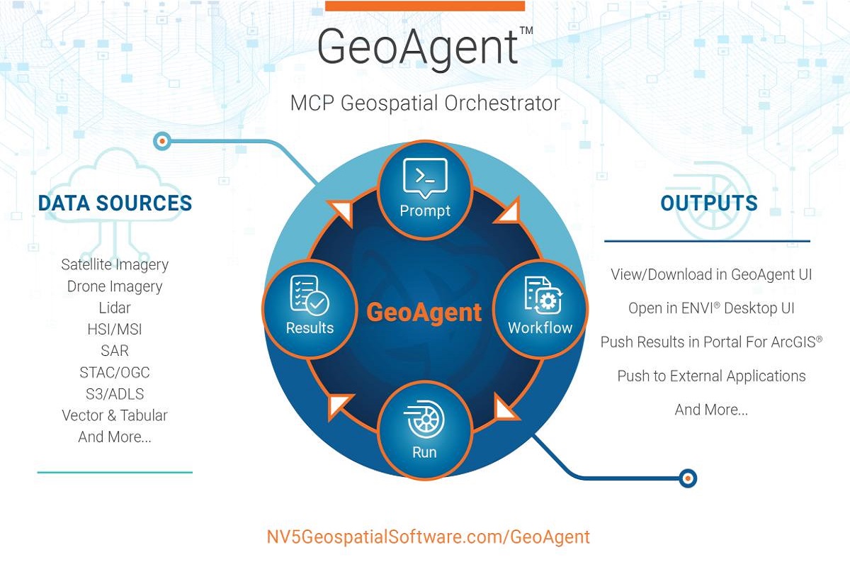
The same principle can extend to satellite imagery, aerial photogrammetry, GIS databases and infrastructure management platforms. An important requirement is interoperability. Geospatial organizations frequently operate across multiple software environments, making it essential that AI systems integrate existing technologies rather than impose entirely new processing ecosystems. NV5's GeoAgent platform is presented as an example of this approach, designed to coordinate geospatial operations through natural-language interaction while connecting different analytical environments.
Human-in-the-Loop: Why Geospatial Expertise Remains Essential
One of the most significant implications of operational GeoAI concerns the evolving role of geospatial professionals. Although agentic systems can automate repetitive tasks, expert supervision remains essential for ensuring the reliability and appropriate interpretation of results. This is particularly important in LiDAR applications, where point density, classification quality, acquisition geometry and local environmental conditions can substantially influence analytical outcomes.
A human-in-the-loop approach introduces review stages throughout the workflow, allowing analysts to approve input datasets, inspect potentially problematic areas, modify processing parameters and validate outputs before they are distributed or incorporated into operational systems. Rather than eliminating specialist expertise, this model shifts professional responsibilities towards workflow design, quality assurance and interpretation.
Where Operational GeoAI Can Deliver Immediate Benefits
According to Vincent, some of the most promising applications involve activities characterized by large data volumes and repetitive processing requirements. These include:
- Automated quality assurance and quality control for LiDAR and imagery datasets.
- Asset inventory and geospatial feature extraction.
- Classification and prioritization of extensive image archives.
- Coordination of multi-sensor processing workflows.
- Change detection and infrastructure monitoring.
The potential benefits concern not only processing speed but also the ability to make analytical procedures more consistent and repeatable. However, measurable improvements depend on data quality, system integration, validation procedures and the characteristics of each operational environment.
From Geospatial Analysis to Operational Decision-Making
The development of agentic GeoAI also creates opportunities for more accessible interaction with complex geospatial information.
A user could request an assessment of changes along an infrastructure corridor using natural language. An integrated system could then identify suitable datasets, execute the necessary analytical operations and generate a map or report for specialist validation.
Such capabilities could support infrastructure maintenance, environmental monitoring, natural resource management and territorial planning.
Nevertheless, the transition from demonstration to operational deployment requires careful consideration of data governance, traceability, interoperability and the reliability of automated outputs.
NV5 addresses these requirements through its GeoAI Acceleration Program, which encompasses readiness assessment, data preparation, workflow development and ongoing operational management.
Towards a New Generation of Geospatial Intelligence
The evolution of GeoAI suggests a broader transformation in the relationship between geospatial data, software and professional expertise. In the near term, the priority is likely to be the implementation of reliable, repeatable workflows that reduce manual processing without compromising analytical quality. Over longer periods, increasingly interconnected systems may support continuous monitoring of geographic change, maintaining a traceable record of acquisitions, analyses, expert reviews and operational decisions. For the geospatial sector, the most important development may therefore be not the emergence of another AI model, but the capacity to integrate existing technologies into coherent, transparent and human-supervised processes.
The transition from experimental GeoAI to operational intelligence will ultimately depend on how effectively automation, interoperability and geospatial expertise can work together.
Sources
- NV5, From AI Pilots to Operational GeoAI – NV5 Featured in LIDAR Magazine, October 1, 2026.
- LIDAR Magazine, GeoAI in Practice: A Conversation with NV5's Chancee Vincent, September 27, 2026.
- NV5, GeoAI Solutions and GeoAI Acceleration Program.