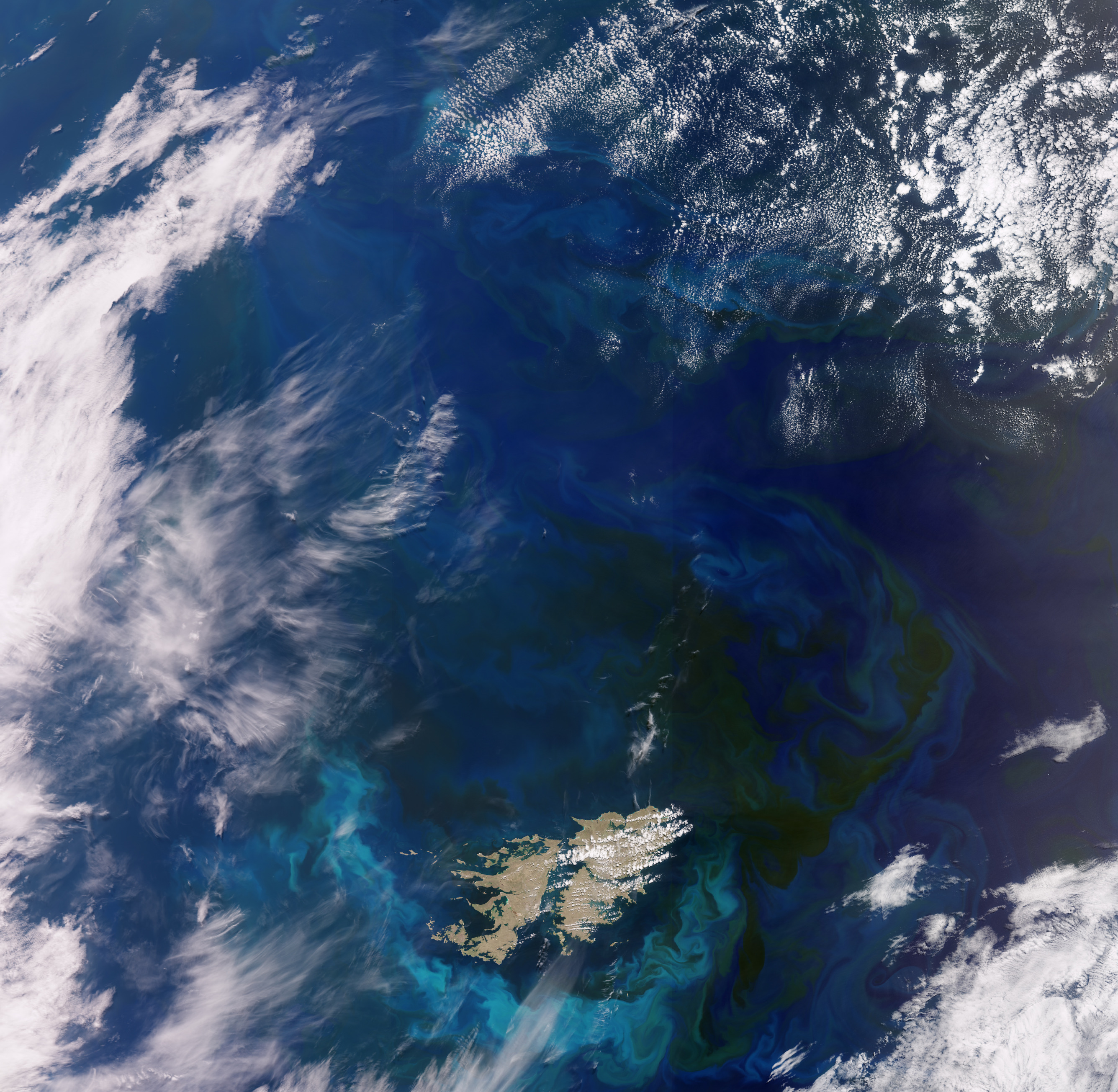
Questa ampia veduta ripresa dalla missione Copernicus Sentinel-3 mostra le isole Falkland nell'Oceano Atlantico meridionale.
Le Isole Falkland, conosciute anche come Isole Malvine, si trovano a circa 500 km a nord-est della punta meridionale del Sud America. Le Falkland comprendono due isole principali - le Falkland Occidentali e le Falkland Orientali - e centinaia di isole e isolotti più piccoli, che coprono una superficie che ammonta a circa cinque volte quella del Lussemburgo.
L'arcipelago deve il suo nome al Falkland Sound, lo stretto che separa le Falkland Occidentali dalle Falkland Orientali. Sulla costa nord-orientale delle Falkland Orientali si trova la capitale Stanley, che ospita oltre i tre quarti della popolazione.
Il paesaggio delle isole Falkland comprende catene montuose, distese pianeggianti, coste frastagliate e scogliere. Le colline corrono da est a ovest attraverso le regioni settentrionali delle due isole principali, con i punti più alti raggiunti dal Monte Adam sulle Falkland occidentali e dal Monte Usborne sulle Falkland orientali.
Le alghe dell'Atlantico meridionale spesso si sviluppano velocemente in enormi fioriture che galleggiano e vengono trasportate dalle serpeggianti correnti oceaniche. In questa immagine, acquisita nel novembre 2023, si possono vedere impressionanti vortici verdi e blu che coprono più di 360.000 kmq intorno alle Isole Falkland. I diversi colori sono il risultato della luce solare che si riflette sulla clorofilla contenuta nelle microscopiche piante.
Le fioriture in quest'area sono abbastanza comuni a causa della convergenza di due forti correnti oceaniche: la corrente più calda e povera di nutrienti proveniente dal Brasile - che scorre verso sud - e la corrente più fredda delle Falkland, che viaggia verso nord. Quando le due correnti si incontrano, la turbolenza risultante provoca correnti di risalita (upwelling), che possono portare grandi quantità di nutrienti in superficie, in parte responsabili delle fioriture di fitoplancton. Queste fioriture sono un'importante fonte di cibo per molte specie marine.
Aiutare a mappare le fioriture algali e fornire informazioni critiche per le operazioni marine sono solo alcuni dei modi in cui i due satelliti Sentinel-3 vengono utilizzati per il programma europeo Copernicus. Dotato di una serie di strumenti all'avanguardia, Copernicus Sentinel-3 misura sistematicamente gli oceani, i territori, il ghiaccio e l'atmosfera della Terra, allo scopo di monitorare e comprendere le dinamiche globali su larga scala.
Scarica immagine MedRes (1,81 - .JPG)
Scarica immagine HighRes (81,34 GB - .TIF)
---
Falkland Islands
This wide view from the Copernicus Sentinel-3 mission pictures the Falkland Islands in the South Atlantic Ocean.
The Falkland Islands, also known as Islas Malvinas, lie around 500 km northeast of the southern tip of South America. The Falklands comprise two main islands, West Falkland and East Falkland, and hundreds of smaller islands and islets that cover a land area that totals around five times that of Luxembourg.
The archipelago owes its name to Falkland Sound, the strait that separates West Falkland from East Falkland. On the northeast shore of East Falkland lies the capital Stanley, which is home to over three-quarters of the population.
The landscape of the Falkland Islands comprises mountain ranges, flat plains, rugged coastlines and cliffs. Hills run east-west across the northern parts of the two main islands, with the highest points being Mount Adam on West Falkland and Mount Usborne on East Falkland.
Algae in the South Atlantic often quickly develop into enormous blooms which float and are carried with the meandering ocean currents. In this image, captured in November 2023, impressive green and blue swirls covering more than 360 000 sq km can be seen around the Falkland Islands. The different colours are the result of sunlight reflecting off the chlorophyll contained in the microscopic plants.
Blooms in this area are quite common owing to the convergence of two strong oceanic currents: the warmer low-nutrient current from Brazil flowing southward and the colder Falkland current that travels northward. When the two currents meet, the resulting turbulence causes upwelling, which can drive large amounts of nutrients to the surface, which is partly responsible for phytoplankton blooms. These blooms are an important food source for many marine species.
Helping to map algal blooms and providing critical information for marine operations are just some of the ways that the two Sentinel-3 satellites are used for Europe’s Copernicus programme. Carrying a suite of cutting-edge instruments, Copernicus Sentinel-3 measures systematically Earth’s oceans, land, ice and atmosphere to monitor and understand large-scale global dynamics.
[Credits: Credits: contains modified Copernicus Sentinel data (2023), processed by ESA - Translation: Gianluca Pititto]


