

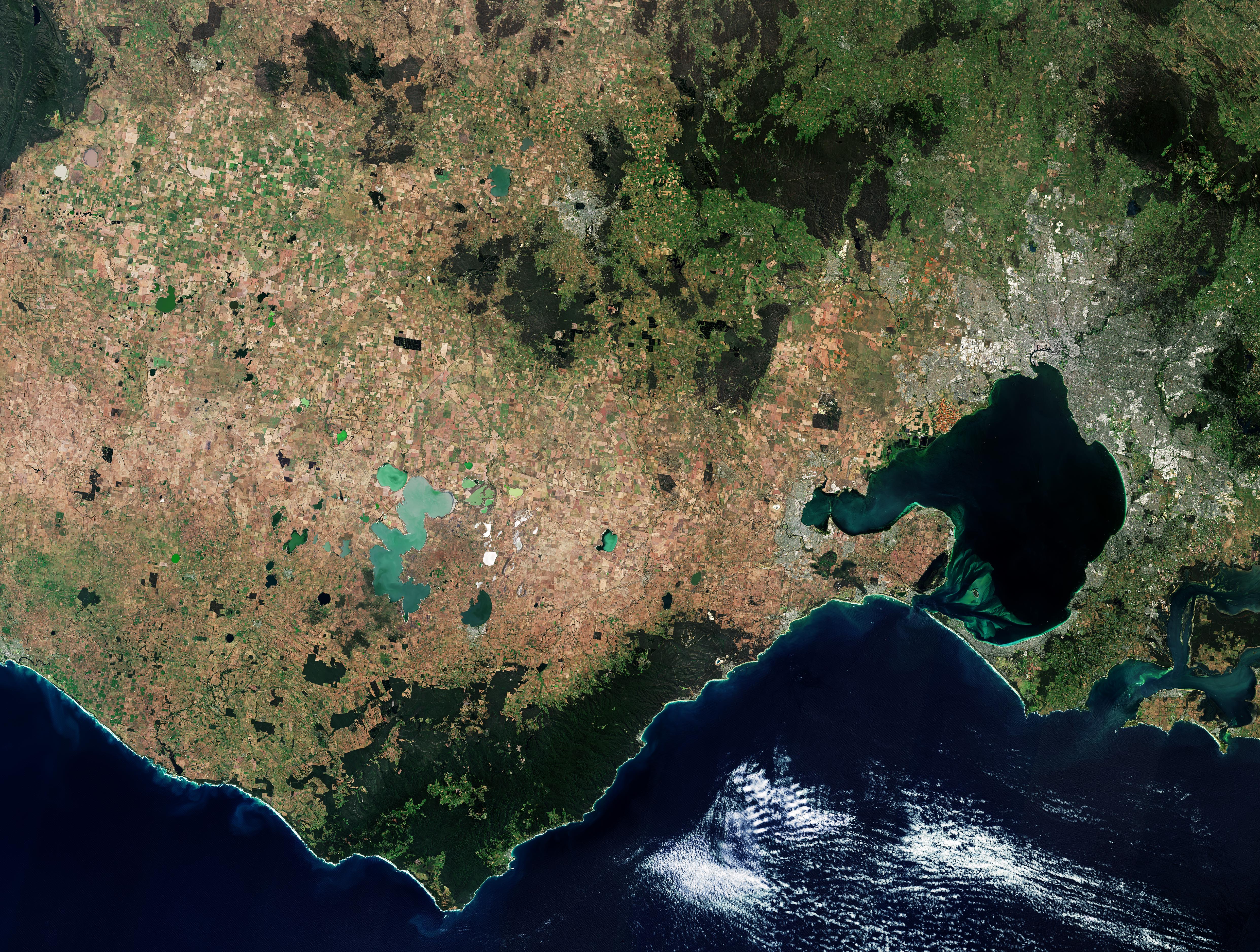
Questa immagine di Copernicus Sentinel-2 mostra parte di Victoria, uno stato nel sud-est dell'Australia. Melbourne, la capitale di Victoria, è visibile nella parte destra dell'immagine.
Dalle cime delle montagne alle fitte gole della foresta pluviale e le coste spettacolari, Victoria ospita una ricca varietà di paesaggi. Un certo numero di parchi nazionali può essere individuato in verde scuro nella parte superiore dell'immagine, mentre il terreno brunastro delle Pianure Vulcaniche Occidentali può essere individuato sulla sinistra.
Le Pianure Vulcaniche Occidentali sono in gran parte pianeggianti e aperte, punteggiate da coni vulcanici e maar (cratere costituito da una cavità imbutiforme – NdT), oltre che da laghi e paludi. I laghi nell'immagine appaiono in diversi colori, che vanno da varie tonalità di verde al bianco, a seconda della concentrazione di minerali delle loro acque.
Il lago Corangamite, il più grande lago salato permanente dell'Australia, è visibile vicino al centro dell'immagine, mentre il lago Beeac può essere riconosciuto grazie alle sue acque bianco latte.
Grazie alla sua origine vulcanica, l’area pianeggiante presenta alcuni dei terreni più fertili di Victoria ed è generalmente utilizzata per scopi agricoli. Un mosaico di campi agricoli si mostra diffuso in tutta la regione.
La più grande insenatura lungo la costa è Port Phillip Bay, che si apre nello stretto di Bass attraverso un canale breve e stretto. Confina a ovest con la penisola di Bellarine e a est con la penisola di Mornington.
Diverse tonalità di verde nella baia denotano acque poco profonde - la profondità media della baia è di 8 m - oppure sedimenti e particelle disperse, che rimangono intrappolate prima di fluire infine nell'oceano.
La città di Melbourne si trova all'inizio della baia di Port Philip. Il fiume Yarra può essere visto come una linea scura e tortuosa nell'immagine, mentre raggiunge la Greater Melbourne prima di sfociare nella baia di Port Philip.
La grande area urbana visibile in grigio a sud-ovest di Melbourne è Geelong, la seconda città di Vittoria più grande dopo Melbourne.
A est di Port Phillip si trova la Western Port Bay, dominata dalle isole French e Phillip.
Scarica immagine LowRes (2,05 - .JPG)
Scarica immagine HighRes (4,75 - .JPG)
---
Victoria, Australia
This Copernicus Sentinel-2 image features part of Victoria, a state in southeast Australia. Melbourne, Victoria’s capital, is visible in the right of the image.
From mountain peaks to dense rainforest gullies and dramatic coastlines, Victoria is home to a rich variety of landscapes. A number of national parks can be seen in dark green in the top of the image, while the brownish terrain of the Western Volcanic Plains can be seen in the left.
The Western Volcanic Plains is largely a flat, open plain, dotted with volcanic cones and maars, as well as lakes and swamplands. Lakes in the image appear in different colours, ranging from various shades of green to white, depending on the mineral concentration of their waters.
Lake Corangamite, Australia's largest permanent saltwater lake, is visible near the centre of the image, while Lake Beeac can be seen with its milky-white waters.
Thanks to its volcanic origin, the plain has some of the most fertile soils in Victoria and is generally used for agricultural purposes. A patchwork of agricultural fields can be seen scattered across the region.
The largest inlet along the coastline is Port Phillip Bay which opens into the Bass Strait through a short, narrow channel. It is bounded by the Bellarine Peninsula to the west and the Mornington Peninsula to the east.
Different shades of green in the bay either denote shallow waters — the average depth of the bay is 8 m — or sediment and dispersed particles that remain trapped before eventually flowing into the ocean.
The city of Melbourne sits at the head of Port Philip Bay. The Yarra River can be seen as a dark, winding line in the image, as it reaches Greater Melbourne before emptying into Port Philip Bay.
The large urban area visible in grey southwest of Melbourne is Geelong, the second largest Victorian city behind Melbourne.
To the east of Port Phillip lies Western Port Bay which is dominated by French Island and Phillip Island.
[Credits: contains modified Copernicus Sentinel data (2024), processed by ESA - Translation: Gianluca Pititto]
