

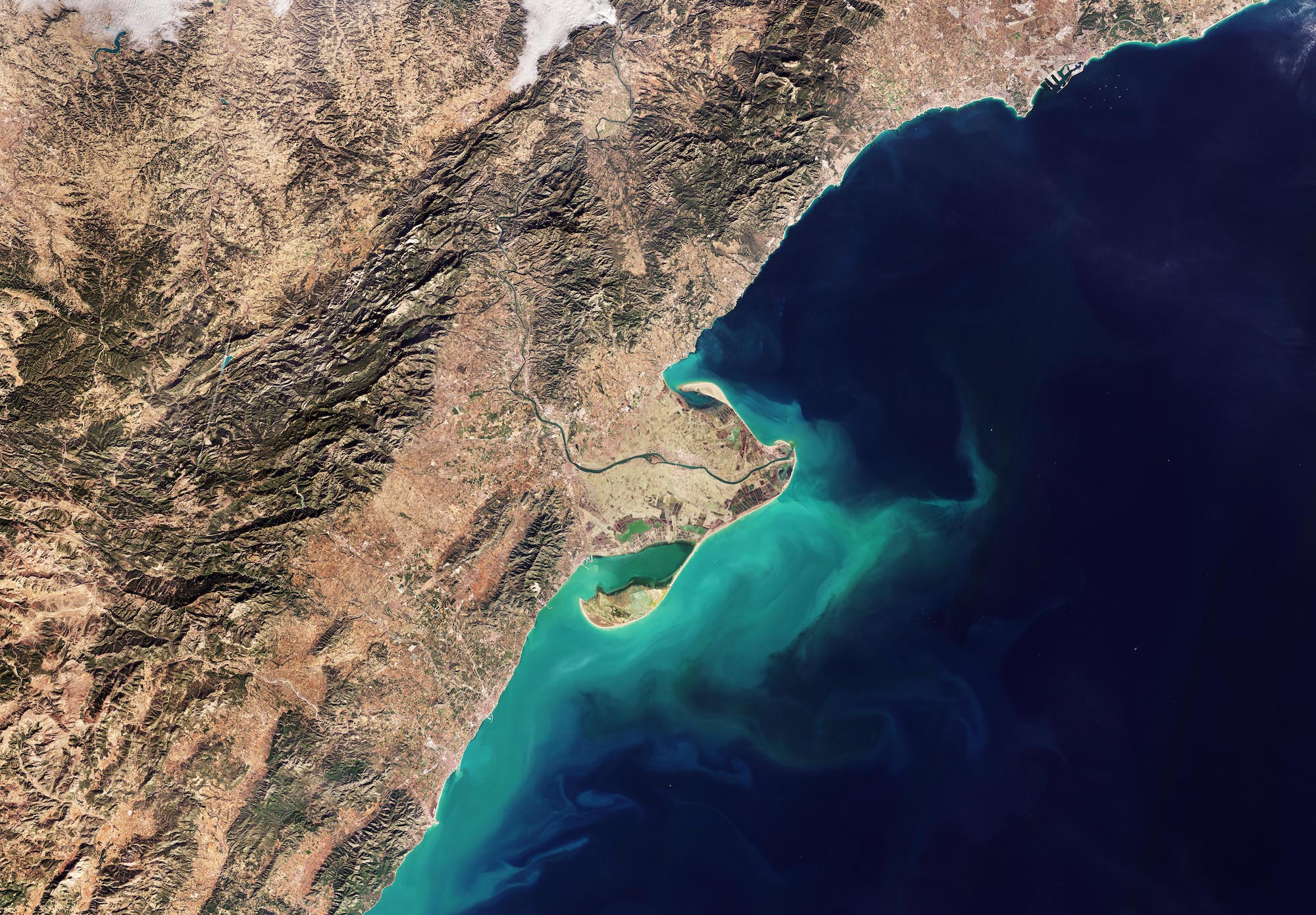
Questa immagine di Copernicus Sentinel-2 mostra il delta del fiume Ebro sulla costa nord-orientale della Spagna.
Con i suoi 910 km di estensione lungo il nord della Spagna, il fiume Ebro è il secondo fiume più lungo della penisola iberica. Nell'immagine può essere visto come una linea verde che si snoda attraverso la penisola, prima di sfociare nel Mediterraneo dando forma al Delta dell'Ebro.
Il fiume Ebro scarica più acqua in mare di qualsiasi altro fiume della Spagna. Quando i sedimenti sospesi fluiscono dalla foce del fiume, essi tingono le acque costiere di una tonalità turchese.
Con una superficie di circa 320 kmq, il Delta dell'Ebro è una delle più grandi zone umide di tutto il Mediterraneo occidentale.
La maggior parte del delta è costituito della Riserva Naturale del Delta dell'Ebro. Con le sue zone umide protette, le spiagge, le paludi, le saline e gli estuari, questa riserva offre un habitat naturale per numerosi uccelli migratori e acquatici.
Zoomando sulla penisola, diverse lagune verdi punteggiano la costa, mentre gran parte delle aree interne sono dominate da campi coltivati, principalmente risaie. Questi campi presentano una gamma di colori a seconda del diverso stadio di crescita delle colture. La città di Amposta si trova al centro della penisola, a cavallo del fiume Ebro.
La regione costiera che circonda la penisola mostra un doppio sistema di catene montuose intervallate da pianure. Questi terreni sono prevalentemente agricoli e su di essi vengono coltivate colture come grano, orzo, frutta e ortaggi.
La città di Tarragona, che ospita uno dei porti più grandi della Spagna, è visibile lungo la costa nell'angolo in alto a destra. Le navi al largo della costa possono essere riconosciute come puntini colorati nelle acque scure. Tarragona è un importante mercato agricolo ed anche una meta turistica, grazie alle bellissime spiagge prossime alla città.
Con la sua rivisitazione di cinque giorni e la copertura globale, Copernicus Sentinel-2 offre eccellenti opportunità per il monitoraggio dell'agricoltura sia a livello regionale che globale. I suoi dati possono aiutare a valutare l'uso e lo sviluppo del suolo agricolo, le condizioni delle colture e le previsioni di rendimento.
Scarica immagine HiRes (4,90 - .JPG)
Scarica immagine HighRes (724,31 - .TIF)
---
The Ebro Delta
This Copernicus Sentinel-2 image shows the delta of the Ebro River on the northeast coast of Spain.
Stretching across 910 km of northern Spain, the Ebro River is the second-longest river in the Iberian Peninsula. In the image, it can be seen as a green line winding its way through the peninsula before flowing into the Mediterranean, shaping the Ebro Delta.
The Ebro River discharges more water into the sea than any other river in Spain. As suspended sediment flows from the river’s mouth, it tints the coastal waters with a turquoise hue.
Covering an area of about 320 sq km, the Ebro Delta is one of the largest wetlands in the western Mediterranean region.
Most of the delta comprises the Ebro Delta Nature Reserve. With its protected wetlands, beaches, marshes, salt pans and estuaries, this reserve provides a natural habitat for numerous migratory birds and waterfowl.
Zooming on the peninsula, several green lagoons dot the coastline, while much of the inland areas are dominated by agricultural fields, primarily rice paddies. These fields display a range of colours depending on the different stage of growth of the crops. The city of Amposta is in the centre of the peninsula, straddling the Ebro River.
The coastal region surrounding the peninsula features a double system of mountain chains interspersed with plains. These plateaus are predominantly cultivated where crops such as wheat, barley, fruits and vegetables are grown.
The city of Tarragona, home to one of the largest ports in Spain, is visible along the coast in the top right corner. Ships off the coast can be seen as colourful dots in the dark waters. Tarragona is an important agricultural market and a tourist destination thanks to the beautiful beaches near the city.
With its five-day revisit and global coverage, Copernicus Sentinel-2 offers excellent opportunities for both regional and global agriculture monitoring. Its data can help to assess agricultural land use and trends, crop conditions and yield forecasts.
[Credits: contains modified Copernicus Sentinel data (2024), processed by ESA - Translation: Gianluca Pititto]
